IMAGES TAKEN NEAR TO
Chichester Drive West, BRIGHTON, BN2 8SF
Introduction
This page details the photographs taken nearby to Chichester Drive West, BN2 8SF by members of the Geograph project.
The Geograph project started in 2005 with the aim of publishing, organising and preserving representative images for every square kilometre of Great Britain, Ireland and the Isle of Man.

There are currently over 7.5m images from over14,400 individuals and you can help contribute to the project by visiting https://www.geograph.org.uk
Image Map
Images are licensed for reuse under creativecommons.org/licenses/by-sa/2.0
Notes
- Clicking on the map will re-center to the selected point.
- The higher the marker number, the further away the image location is from the centre of the postcode.
Image Listing (65 Images Found)
Images are licensed for reuse under creativecommons.org/licenses/by-sa/2.0
Image
Details
Distance
1

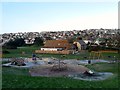
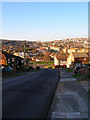
Chichester Drive West
Taken from the junction with Saltdean Vale. Built from the 1920s onwards by Charles Neville, also the builder of nearby Peacehaven, Saltdean has aged better simply because the design and layout of the roads matched the contours of the land utilising the curves and not just driving roads in a straight line.
Image: © Simon Carey
Taken: 15 Mar 2009
0.05 miles
2

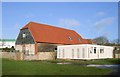
Saltdean Barn
This building, within Saltdean Park, is Grade II listed. It is an early Victorian Sussex barn with a large waggon doorway on the north side. The building is now used as a nursery school
Image: © Kevin Gordon
Taken: 8 Dec 2008
0.06 miles
3
Saltdean Barn, Saltdean
The flint barn dates from the late 18th century and until the 1920s was the one of the few structures in Saltdean Bottom. It is now used a pre-school nursery.
Image: © Simon Carey
Taken: 16 Jan 2016
0.07 miles
4
Saltdean Barn
Originally built in the 18th century and until 1922 the only building in the valley. Now grade II listed it was converted in 2005 into the Boomerang Kids Club for children aged eight and over. The barn is located in Saltdean Park.
Image: © Simon Carey
Taken: 16 Dec 2007
0.07 miles
5
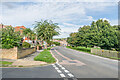
Arundel Drive West
Residential road forming the western perimeter of Saltdean Park.
Image: © Ian Capper
Taken: 20 Sep 2022
0.08 miles
6
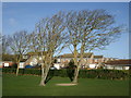
Trees in Saltdean Park
Arundel Drive West is in the background
Image: © Paul Gillett
Taken: 26 Dec 2012
0.08 miles
8
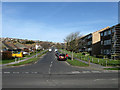
Chichester Drive East
Looking down towards the junction with Saltdean Vale. The layout of the housing gives some idea how the new suburb was built into the contours of the Downs.
Image: © Simon Carey
Taken: 16 Dec 2007
0.09 miles
9
Lustrells Vale
Linking Saltdean Vale with Bishopstone Drive further up the hill.
Image: © Simon Carey
Taken: 15 Mar 2009
0.09 miles
10
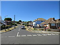
Founthill Avenue, Saltdean
Founthill Avenue is a residential road in Saltdean, on the Sussex coast near Brighton.
Image: © Malc McDonald
Taken: 24 Jul 2022
0.10 miles