IMAGES TAKEN NEAR TO
Linchmere Avenue, BRIGHTON, BN2 8LE
Introduction
This page details the photographs taken nearby to Linchmere Avenue, BN2 8LE by members of the Geograph project.
The Geograph project started in 2005 with the aim of publishing, organising and preserving representative images for every square kilometre of Great Britain, Ireland and the Isle of Man.

There are currently over 7.5m images from over14,400 individuals and you can help contribute to the project by visiting https://www.geograph.org.uk
Image Map
Images are licensed for reuse under creativecommons.org/licenses/by-sa/2.0
Notes
- Clicking on the map will re-center to the selected point.
- The higher the marker number, the further away the image location is from the centre of the postcode.
Image Listing (112 Images Found)
Images are licensed for reuse under creativecommons.org/licenses/by-sa/2.0
Image
Details
Distance
1
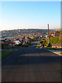
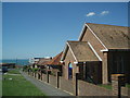
Oaklands Avenue
Looking across the suburb of Saltdean constructed from 1922 onwards on what was open downland. The designer was GW Neville who also built nearby Peacehaven though in this case rather than layout the houses in straight lines he utilised the flow of the contours to construct his roads.
Image: © Simon Carey
Taken: 16 Dec 2007
0.02 miles
2
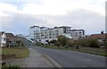
Grand Ocean
View from the west taken in Chichester Drive East of the former Ocean Hotel
Image: © Paul Gillett
Taken: 28 Dec 2013
0.05 miles
3
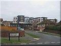
Oaklands Avenue, Saltdean
A residential road that runs from Greenbank Avenue to Bannings Vale that was marked out during the 1920s. The section in view here approaching the crossroads with Linchmere Avenue was developed on the northern side during the 1930s with the southern section to the east of the crossroads added in the 1960s and that to the west during the 1970s.
Image: © Simon Carey
Taken: 28 Jan 2016
0.06 miles
4
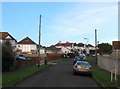
Linchmere Avenue, Saltdean
A residential road that runs from Arundel Drive East to Rodmell Avenue. The section in view here, north of Oaklands Avenue, was developed in the 1930s.
Image: © Simon Carey
Taken: 28 Jan 2016
0.06 miles
5
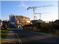
Wicklands Avenue
The cranes are currently renovating the former Ocean Hotel into new apartments. The main body of the former hotel is being kept but the extensions have demolished and are going to replaced by new blocks.
Image: © Simon Carey
Taken: 16 Dec 2007
0.06 miles
6
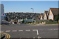
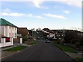
Saltdean Townscape
Viewed along Wicklands Avenue.
Image: © Oast House Archive
Taken: 10 Oct 2010
0.08 miles
7
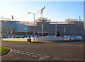
Grand Ocean
The former Ocean Hotel being redeveloped into the new Grand Ocean apartments. Currently under wraps but the developers are keeping the ariginal Art Deco facade. See http://www.mybrightonandhove.org.uk/images/uploaded/scaled/ocean_hotel_saltdean1_s.jpg for original view. The hotel was built in 1937 and commandeered by the fire service during World War Two. After a rocky post war period it was purchased by Butlins in 1953 who owned it until 1999 when it was sold onto the Grand Hotel Group who kept it open until closing it in January 2005. Planning permission was granted in June 2005 for its redevelopment though the original structure will remain and the new blocks will retain the shape of the former hotel.
Image: © Simon Carey
Taken: 16 Dec 2007
0.08 miles
8
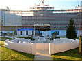
Grand Ocean
Taken from the far side of the Longridge Avenue and Wicklands Avenue crossroads. See Image for the full history of the building.
Image: © Simon Carey
Taken: 16 Dec 2007
0.08 miles
9
Longridge Avenue, Saltdean
Viewed from the junction with Bevendean Avenue, in the foreground is St Martin's URC church, further back can be seen the newly refurbished Grand Ocean Hotel
Image: © Paul Gillett
Taken: 30 May 2009
0.08 miles
10
Rear view of Grand Ocean
see Image for front view
Image: © Paul Gillett
Taken: 27 Dec 2011
0.09 miles