IMAGES TAKEN NEAR TO
Westfield Avenue, BRIGHTON, BN2 8HU
Introduction
This page details the photographs taken nearby to Westfield Avenue, BN2 8HU by members of the Geograph project.
The Geograph project started in 2005 with the aim of publishing, organising and preserving representative images for every square kilometre of Great Britain, Ireland and the Isle of Man.

There are currently over 7.5m images from over14,400 individuals and you can help contribute to the project by visiting https://www.geograph.org.uk
Image Map
Images are licensed for reuse under creativecommons.org/licenses/by-sa/2.0
Notes
- Clicking on the map will re-center to the selected point.
- The higher the marker number, the further away the image location is from the centre of the postcode.
Image Listing (48 Images Found)
Images are licensed for reuse under creativecommons.org/licenses/by-sa/2.0
Image
Details
Distance
1
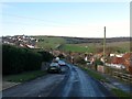
Westfield Avenue, Saltdean
A residential road heading east from Saltdean Vale before splitting into Image This section is all that remains of the original road which was laid out in the 1920s but not developed until the 1950s.
Image: © Simon Carey
Taken: 16 Jan 2016
0.04 miles
3
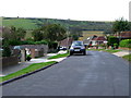
Vale Road, Saltdean
A short residential road that links Saltdean Vale to Stanmer Avenue that had been developed by 1952.
Image: © Simon Carey
Taken: 28 Jan 2016
0.06 miles
5
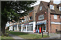
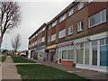
Shops at Saltdean Vale
The post box is BN2 167
Image: © Keith Edkins
Taken: 14 Sep 2018
0.07 miles
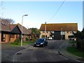
6
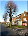
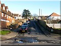
138-152, Saltdean Vale, Saltdean
Number 138 on the right had been built by 1952 and was a post office for many years though it is now the SNK Convenience Store. Numbers 140-152 were added sometime during the 1950s and form a small parade of shops for the residents of the northern end of Saltdean.
Image: © Simon Carey
Taken: 28 Jan 2016
0.07 miles
7
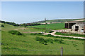
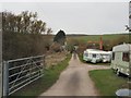
Towards Saltdean
Looking down the valley from near Pickers Hill Farm.
Image: © Robin Webster
Taken: 19 May 2010
0.07 miles
8
Westfield Avenue North and South, Saltdean
Westfield Avenue South is on the left and runs east to meet Hempstead Road. Westfield Avenue North is at the bottom of the slope and heads north westwards to Coombe Farm. Both join at the western end to become Image The original course of Westfield Avenue, as laid out in the 1920s was along the middle of the green. The current layout dates from the late 1940s. High Hill can be seen in the distance.
Image: © Simon Carey
Taken: 16 Jan 2016
0.08 miles
9
Saltdean Vale - Path to Nursery
To the North of Saltdean, near Coombe Farm
Image: © Paul Gillett
Taken: 11 Apr 2010
0.08 miles
10
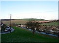
Looes Barn Close, Saltdean
Looes Barn is one of three flint barns that occupied Saltdean Bottom prior to the construction of the suburb of Saltdean, the others being Saltdean Park and Newlands Barn, both now converted. This flint barn dates from the early 19th century and remained in agricultural use much longer than the other two. By the late 1980s it was derelict and wouldn't be restored until 2002-03 when it was converted into a pair of residential dwellings and its former yard becoming a cul de sac off Saltdean Vale.
Image: © Simon Carey
Taken: 16 Jan 2016
0.08 miles