IMAGES TAKEN NEAR TO
Wivelsfield Road, BRIGHTON, BN2 8FP
Introduction
This page details the photographs taken nearby to Wivelsfield Road, BN2 8FP by members of the Geograph project.
The Geograph project started in 2005 with the aim of publishing, organising and preserving representative images for every square kilometre of Great Britain, Ireland and the Isle of Man.

There are currently over 7.5m images from over14,400 individuals and you can help contribute to the project by visiting https://www.geograph.org.uk
Image Map
Images are licensed for reuse under creativecommons.org/licenses/by-sa/2.0
Notes
- Clicking on the map will re-center to the selected point.
- The higher the marker number, the further away the image location is from the centre of the postcode.
Image Listing (24 Images Found)
Images are licensed for reuse under creativecommons.org/licenses/by-sa/2.0
Image
Details
Distance
1
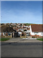
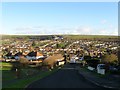
North Western Edge of Saltdean
Viewed from Saltdean Vale with the housing in the distance and the beginning of open downland on the right.
Image: © Simon Carey
Taken: 15 Mar 2009
0.06 miles
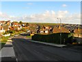
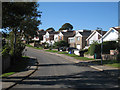
2
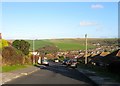
Wivelsfield Road, Saltdean
A residential road that runs between Falmer Avenue and Tumulus Avenue that appears to have been laid out by 1951 but only contained three houses. By the end of the 1950s the whole road had been developed. See also Image Coombe Farm can be seen in the distance.
Image: © Simon Carey
Taken: 28 Jan 2016
0.08 miles
3
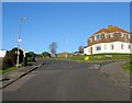
Falmer Avenue, Saltdean
The northern end of Image with the western junction of Image to the right. The house on the right had been built by 1951 before many of the others in the vicinity.
Image: © Simon Carey
Taken: 28 Jan 2016
0.12 miles
4
Falmer Avenue
Edge of housing estate on edge the South Downs.
Image: © Oast House Archive
Taken: 10 Oct 2010
0.12 miles
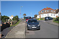
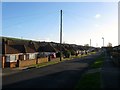
5
Wivelsfield Road, Saltdean
The northern part of the road that heads down to Tumulus Road. Out of shot to the right the road turns south westwards and heads towards Falmer Avenue, see Image
In the distance to the left are Image that contain local shops. Beyond are two green rectangles, that to the left lies in the middle of Image whilst to its right is another that forms the middle of Image Continuing southwards a smaller area of green marks the location of Image and another on the far right marks the line of Image All those named roads form junctions to the east with Image Continuing eastwards three more lines of housing form Image, Arlington Gardens and Image respectively. All of those roads form junctions with Greenbank Avenue further to the east which borders onto Telscombe Tye. Below the Tye to the north Coombe Farm can just be made out.
Image: © Simon Carey
Taken: 28 Jan 2016
0.14 miles
6
Bishopstone Drive, Saltdean
A residential road that runs from Westmeston Avenue to Lustrells Crescent. It was marked out in the 1920s and was originally known as Newlands Road though wasn't fully developed until the 1960s when the road acquired its current name.
Image: © Simon Carey
Taken: 28 Jan 2016
0.16 miles
7
Perry Hill, Saltdean
A residential road that runs between Tumulus Road and Lustrells Crescent that was developed in the late 1950s.
Image: © Simon Carey
Taken: 28 Jan 2016
0.17 miles
8
Bishopstone Drive, Saltdean
The name of the bus stop is Falmer Avenue.
Image: © Robin Webster
Taken: 19 May 2010
0.18 miles
10
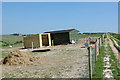
Sheds on a slope
They really are built directly on the sloping ground.
Image: © Robin Webster
Taken: 19 May 2010
0.20 miles