IMAGES TAKEN NEAR TO
Lustrells Close, BRIGHTON, BN2 8AS
Introduction
This page details the photographs taken nearby to Lustrells Close, BN2 8AS by members of the Geograph project.
The Geograph project started in 2005 with the aim of publishing, organising and preserving representative images for every square kilometre of Great Britain, Ireland and the Isle of Man.

There are currently over 7.5m images from over14,400 individuals and you can help contribute to the project by visiting https://www.geograph.org.uk
Image Map
Images are licensed for reuse under creativecommons.org/licenses/by-sa/2.0
Notes
- Clicking on the map will re-center to the selected point.
- The higher the marker number, the further away the image location is from the centre of the postcode.
Image Listing (30 Images Found)
Images are licensed for reuse under creativecommons.org/licenses/by-sa/2.0
Image
Details
Distance
1
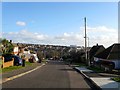
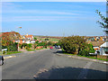
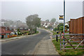
Falmer Avenue, Saltdean
A residential road that runs westwards from Chiltington Way continuing north of Bishopstone Drive becoming a dead end after the junction with Wivelsfield Road. Laid out in the 1930s though only one house had been built by 1951, however, development soon followed and was largely complete by the 1960s. The large building in the distance is the former Ocean Hotel.
Image: © Simon Carey
Taken: 28 Jan 2016
0.08 miles
3
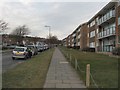
Bishopstone Drive, Saltdean
A residential road that runs from Westmeston Avenue to Lustrells Crescent. It was marked out in the 1920s and was originally known as Newlands Road though wasn't fully developed until the 1960s when the road acquired its current name.
Image: © Simon Carey
Taken: 28 Jan 2016
0.12 miles
4
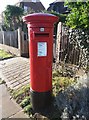
Saltdean: postbox № BN2 169
A GR cipher pillar box in Saltdean, W.Sx.
Image: © mcc
Taken: 28 Dec 2017
0.12 miles
5
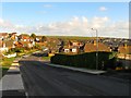
Westmeston Avenue, Saltdean
Looking north from the junction with Chorley Avenue.
Image: © Simon Carey
Taken: 16 Oct 2005
0.13 miles
6
Lustrells Vale
A row of shops, at junction with Chiltington Lane.
Image: © Oast House Archive
Taken: 10 Oct 2010
0.13 miles
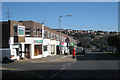
7
Shops in Lustrells Vale
Featuring Healthy U Pharmacy
Image: © Keith Edkins
Taken: 14 Sep 2018
0.13 miles
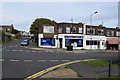
8
Lustrels Vale shops
Shopping area in West Saltdean
Image: © Paul Gillett
Taken: 1 Jan 2010
0.14 miles
9
Bishopstone Drive, Saltdean
The name of the bus stop is Falmer Avenue.
Image: © Robin Webster
Taken: 19 May 2010
0.14 miles
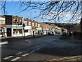
10
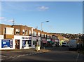
59-87, Lustrells Vale, Saltdean
One of two parades of shops that are located in the road, see also Image These were built in the 1950s to serve the residents of western Saltdean. Number 61 was until recently a sub post office which has since moved to 126 whilst number 87 is a small Co-Op.
Image: © Simon Carey
Taken: 28 Jan 2016
0.14 miles