IMAGES TAKEN NEAR TO
Marine Drive, BRIGHTON, BN2 8AA
Introduction
This page details the photographs taken nearby to Marine Drive, BN2 8AA by members of the Geograph project.
The Geograph project started in 2005 with the aim of publishing, organising and preserving representative images for every square kilometre of Great Britain, Ireland and the Isle of Man.

There are currently over 7.5m images from over14,400 individuals and you can help contribute to the project by visiting https://www.geograph.org.uk
Image Map
Images are licensed for reuse under creativecommons.org/licenses/by-sa/2.0
Notes
- Clicking on the map will re-center to the selected point.
- The higher the marker number, the further away the image location is from the centre of the postcode.
Image Listing (145 Images Found)
Images are licensed for reuse under creativecommons.org/licenses/by-sa/2.0
Image
Details
Distance
1
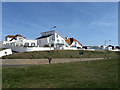
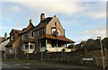
Houses, Marine Drive
Viewed from the cliff top path with the A259 dropping down in the dip between the two. Saltdean and Peacehaven may have designed by the same developer, Charles Neville, but the former has aged better due to the layout of the roads matching the contours and the more interesting architecture parts of which were heavily influenced by the then contemporary cubist and modernist designs which would appear amongst the ubiquitous bungalows.
Image: © Simon Carey
Taken: 15 Mar 2009
0.02 miles
2
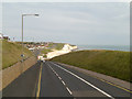
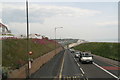
Marine Drive
The A259, between Rottingdean and Saltdean
Image: © David Dixon
Taken: 5 Aug 2012
0.03 miles
3

The Dome, Marine Drive, Saltdean
A distinctive residence located above the cutting carrying the A259. Built sometime in the 1920s and viewed here from the cliffs on the opposite side of the road.
Image: © Simon Carey
Taken: 28 Jan 2016
0.03 miles
6

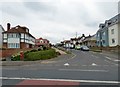
New Houses, Marine Drive, Saltdean
Built in the last year or so on the site of a former single house, number 151, and its large garden. The house had been derelict for many years and burnt down in November 2013 in a blaze that required the attention of seven fire appliances and completely closed the A259 for a number of hours. Arson was the cause with local conspiracy theorists pointing to the fact planning permission had been granted to develop the site a week or so beforehand. Located on the corner of Cranleigh Avenue.
Image: © Simon Carey
Taken: 28 Jan 2016
0.04 miles
8
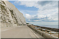
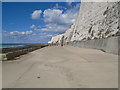
Undercliff Walk
The Undercliff Walk at Rottingdean.
Image: © Ian Capper
Taken: 20 Sep 2022
0.06 miles
10
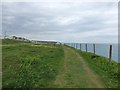
Clifftop path
Between Rottingdean and Saltdean.
Image: © Gerald England
Taken: 27 Apr 2017
0.06 miles