IMAGES TAKEN NEAR TO
Marine Drive, BRIGHTON, BN2 7HQ
Introduction
This page details the photographs taken nearby to Marine Drive, BN2 7HQ by members of the Geograph project.
The Geograph project started in 2005 with the aim of publishing, organising and preserving representative images for every square kilometre of Great Britain, Ireland and the Isle of Man.

There are currently over 7.5m images from over14,400 individuals and you can help contribute to the project by visiting https://www.geograph.org.uk
Image Map
Images are licensed for reuse under creativecommons.org/licenses/by-sa/2.0
Notes
- Clicking on the map will re-center to the selected point.
- The higher the marker number, the further away the image location is from the centre of the postcode.
Image Listing (274 Images Found)
Images are licensed for reuse under creativecommons.org/licenses/by-sa/2.0
Image
Details
Distance
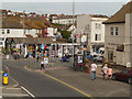
1
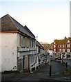
6-20, Marine Drive, Rottingdean
Built as a row of shops in the 1920s on the eastern side of the village crossroads. Some are still in use as shops and services whilst others have been converted into residential dwellings but retain the old shopfront.
Image: © Simon Carey
Taken: 16 Jan 2016
0.00 miles
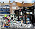
2
PARC charity Shop, Rottingdean
Situated at the southern end of the High Street. PARC is a local children's charity which provides playgrounds and other recreational facilities for teenagers and children in Rottingdean, Ovingdean & Saltdean http://www.rottingdeanvillage.org.uk/charity-book-music-store-parc-charity-shop
Image: © Paul Gillett
Taken: 16 Dec 2012
0.02 miles
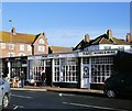
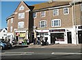
4
Rottingdean, Coach House
Public house on High Street, on two floors. The ground floor has a beamed ceiling and partially exposed shingle walls; counter right, drinking and eating left; TV. Cask ale on offer: Harvey's Best.
Image: © Mike Faherty
Taken: 20 Oct 2018
0.03 miles
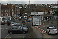
8
Rottingdean Post Office
On Marine Drive.
Image: © Mike Faherty
Taken: 20 Oct 2018
0.03 miles
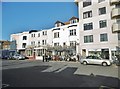
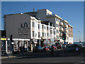
10
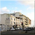
High Street, Rottingdean
A view of the eastern side south of Marine Drive, the A259. The three storey structures date from the Victorian era whilst beyond are St Margaret's Court built in the 1930s and Highcliff Court added in the 1960s.
Image: © Simon Carey
Taken: 31 Dec 2015
0.04 miles