IMAGES TAKEN NEAR TO
Nevill Road, BRIGHTON, BN2 7HG
Introduction
This page details the photographs taken nearby to Nevill Road, BN2 7HG by members of the Geograph project.
The Geograph project started in 2005 with the aim of publishing, organising and preserving representative images for every square kilometre of Great Britain, Ireland and the Isle of Man.

There are currently over 7.5m images from over14,400 individuals and you can help contribute to the project by visiting https://www.geograph.org.uk
Image Map
Images are licensed for reuse under creativecommons.org/licenses/by-sa/2.0
Notes
- Clicking on the map will re-center to the selected point.
- The higher the marker number, the further away the image location is from the centre of the postcode.
Image Listing (328 Images Found)
Images are licensed for reuse under creativecommons.org/licenses/by-sa/2.0
Image
Details
Distance
1
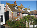
Flint houses on Nevill Road
Attractive terrace of flint cottages near the bottom of the hill that is Nevill Road. Built 1891.
Image: © Oast House Archive
Taken: 10 Oct 2010
0.01 miles
2
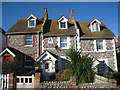
Houses on Nevill Road
Attractive terrace of flint cottages near the bottom of the hill that is Nevill Road. Built 1891.
Image: © Oast House Archive
Taken: 10 Oct 2010
0.02 miles
3
Nevill Road, Rottingdean
The opposite view of Image from the point where the road has been closed to through traffic to Marine Drive. The road climbing the eastern slope is Steyning Road.
Image: © Simon Carey
Taken: 28 Dec 2015
0.02 miles
4
Nevill Road, Rottingdean
The lower end of the road was in existence by the 1870s and later extended westwards to the coast road in the 1920s. Access from the latter was later blocked to prevent the road being used as a rat run. The Royal Mail sorting office was built in the 1960s on the site of a former National School building. See Image for an opposite view.
Image: © Simon Carey
Taken: 28 Dec 2015
0.03 miles
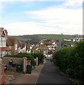
5
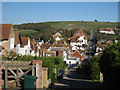
View over Rottingdean
From top of Nevill Hill, a steep private road and footpath down to the High Street, and continuing straight on to Steyning Road.
Image: © Oast House Archive
Taken: 10 Oct 2010
0.03 miles
6
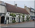
Ye Olde Black Horse
A public house along the High Street of Rottingdean, it is believed to be the oldest entire building in Rottingdean, having been built as early as 1513.
Image: © Mat Fascione
Taken: 23 Aug 2022
0.05 miles
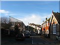
7
Nevill Road
A row of shops on the right and sorting office on left leading onto hill with a private road and public footpath.
Image: © Oast House Archive
Taken: 10 Oct 2010
0.05 miles
8
Rottingdean from Beacon Hill
This is the view from the path between Nevill Road and Beacon Hill, not far from Rottingdean Windmill. It looks down to Rottingdean in its valley.
Image: © Marathon
Taken: 18 Jul 2015
0.05 miles
9
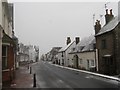
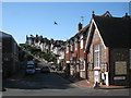
High Street
Looking down a near deserted B2123 as people have heeded the warning to not go out in the weather unless they have to. The light yellow building is Hampton Cottage with Mill Cottage to the left both dating back to the 18th century.
Image: © Simon Carey
Taken: 6 Jan 2010
0.05 miles
10
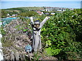
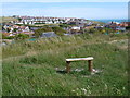
Guardians of the allotments
This is seen from the path between Nevill Road and Beacon Hill. They are at the entrance to some allotments and presumably are intended as a humorous deterrent. Rottingdean is behind.
Image: © Marathon
Taken: 18 Jul 2015
0.05 miles