IMAGES TAKEN NEAR TO
Vicarage Lane, BRIGHTON, BN2 7HD
Introduction
This page details the photographs taken nearby to Vicarage Lane, BN2 7HD by members of the Geograph project.
The Geograph project started in 2005 with the aim of publishing, organising and preserving representative images for every square kilometre of Great Britain, Ireland and the Isle of Man.

There are currently over 7.5m images from over14,400 individuals and you can help contribute to the project by visiting https://www.geograph.org.uk
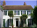
Image Map
Images are licensed for reuse under creativecommons.org/licenses/by-sa/2.0
Notes
- Clicking on the map will re-center to the selected point.
- The higher the marker number, the further away the image location is from the centre of the postcode.
Image Listing (319 Images Found)
Images are licensed for reuse under creativecommons.org/licenses/by-sa/2.0
Image
Details
Distance
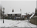
1

Whiteway Lane, Rottingdean
Looking towards the junction with Vicarage Lane with the southern side of The Grange on the right and the Plough Inn at the end of the road behind which on the hill is Beacon Mill.
Image: © Simon Carey
Taken: 28 Jan 2016
0.01 miles
2
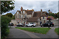
The Plough Inn, Rottingdean
located next to Rottingdean pond in the High Street
Image: © Paul Gillett
Taken: 28 Dec 2011
0.01 miles
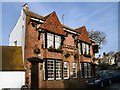
3
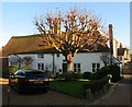
Whipping Post House
Situated next to the village pond few buildings in Rottingdean have such a colourful history. Early Tudor in origin it was once the home of the village's most notorious smuggler, Captain Dunk. When not outsmarting the Revenue Officers Captain Dunk ran a butchers shop on the premises. The extensive cellars must have witnessed countless contraband in their time. Rumour has it that these cellars were also connected to passages leading under the high street to the beach.
The house is named after the whipping post which used to stand just in front of the house where now the Horse Chestnut stands. These posts were used to fasten people so that they could be punished for misdemeanours.
http://www.rggj.net/Rottingdean/pc2.htm
Image: © Paul Gillett
Taken: 3 Jan 2011
0.01 miles
4
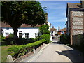
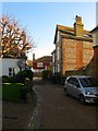
Whipping Post Lane, Rottingdean
Rottingdean is one of the more attractive coastal villages in Sussex. This is Whipping Post Lane, just south of the pond.
Image: © Marathon
Taken: 18 Jul 2015
0.01 miles
5
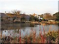
Rottingdean Pond
Rudyard Kipling's House is in the background
Image: © Paul Gillett
Taken: 28 Dec 2011
0.02 miles
6
Rottingdean Library
This is not the good side of the main building (see Image), which dates from c1740 as a vicarage, and altered & enlarged by Sir Edwin Lutyens in 1920. Grade II listing includes the garden walls.
Image: © Keith Edkins
Taken: 14 Sep 2018
0.02 miles
7
Horseshoe Cottage, Whipping Post Lane, Rottingdean
The three storey flint cottage that lies to the south of Image
Image: © Simon Carey
Taken: 28 Dec 2015
0.02 miles
8
Whipping Post House, Whipping Post Lane, Rottingdean
Dating from the 16th century its name derives from the village whipping post and stocks which were once located where the chestnut tree has since been planted.
Image: © Simon Carey
Taken: 28 Dec 2015
0.02 miles
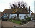
9
Vicarage Terrace
Small row of Victorian cottages off the aptly named Whiteway Lane.
Image: © Simon Carey
Taken: 6 Jan 2010
0.03 miles