IMAGES TAKEN NEAR TO
Marine Drive, BRIGHTON, BN2 7GZ
Introduction
This page details the photographs taken nearby to Marine Drive, BN2 7GZ by members of the Geograph project.
The Geograph project started in 2005 with the aim of publishing, organising and preserving representative images for every square kilometre of Great Britain, Ireland and the Isle of Man.

There are currently over 7.5m images from over14,400 individuals and you can help contribute to the project by visiting https://www.geograph.org.uk
Image Map
Images are licensed for reuse under creativecommons.org/licenses/by-sa/2.0
Notes
- Clicking on the map will re-center to the selected point.
- The higher the marker number, the further away the image location is from the centre of the postcode.
Image Listing (308 Images Found)
Images are licensed for reuse under creativecommons.org/licenses/by-sa/2.0
Image
Details
Distance
2
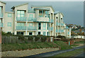
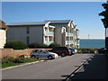
The Cape, Marine Drive, Rottingdean
A block of flats built in 2003 on the site of a former house with an extensive garden. Viewed from Sheep Walk.
Image: © Simon Carey
Taken: 31 Dec 2015
0.01 miles
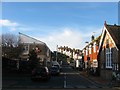
4
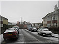
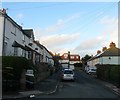
Park Road
Small side road that lies on the eastern slope of Beacon Hill as it descends towards the village of Rottingdean. The road links Marine Drive, the A259, with High Street, the B2123.
Image: © Simon Carey
Taken: 6 Jan 2010
0.02 miles
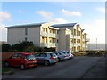
5
Park Crescent, Rottingdean
A cul de sac off Image and the western arm of two that share the same name, see Image for the eastern part. Developed in the 1920s.
Image: © Simon Carey
Taken: 31 Dec 2015
0.03 miles
6
Sheep Walk, Rottingdean
The name of the path that links the A259 to Ovingdean over Beacon Hill. This section passes through the western end of Rottingdean crossing Nevill Road.
Image: © Simon Carey
Taken: 28 Dec 2015
0.05 miles
7
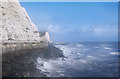
Rough Seas
Rough seas along the south coast on 23rd October 2013
Image: © Kurseong Carl
Taken: 23 Oct 2013
0.05 miles
8
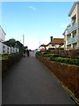
Undercliff Walk
A high tide and rough seas meant keeping to the side of the cliffs on this day.
Image: © Simon Carey
Taken: 31 Dec 2015
0.05 miles
9
Nevill Road, Rottingdean
The lower end of the road was in existence by the 1870s and later extended westwards to the coast road in the 1920s. Access from the latter was later blocked to prevent the road being used as a rat run. The Royal Mail sorting office was built in the 1960s on the site of a former National School building. See Image for an opposite view.
Image: © Simon Carey
Taken: 28 Dec 2015
0.06 miles
10
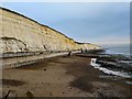
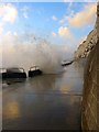
Brighton : Undercliff Walk
"The Undercliff Walk runs from behind Asda in Brighton Marina to the Brighton & Hove City boundary at Saltdean marked by the last rock groyne. A further short section beyond lies the neighbouring Lewes District Council area. The path is just over 5 kms long. Both pedestrians and cyclists can use the Undercliff Walk."- https://www.brighton-hove.gov.uk/content/leisure-and-libraries/seafront/undercliff-walk
Image: © Jim Osley
Taken: 27 Dec 2019
0.07 miles