IMAGES TAKEN NEAR TO
Marine Drive, BRIGHTON, BN2 7GU
Introduction
This page details the photographs taken nearby to Marine Drive, BN2 7GU by members of the Geograph project.
The Geograph project started in 2005 with the aim of publishing, organising and preserving representative images for every square kilometre of Great Britain, Ireland and the Isle of Man.

There are currently over 7.5m images from over14,400 individuals and you can help contribute to the project by visiting https://www.geograph.org.uk
Image Map
Images are licensed for reuse under creativecommons.org/licenses/by-sa/2.0
Notes
- Clicking on the map will re-center to the selected point.
- The higher the marker number, the further away the image location is from the centre of the postcode.
Image Listing (93 Images Found)
Images are licensed for reuse under creativecommons.org/licenses/by-sa/2.0
Image
Details
Distance
1
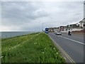
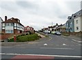
Marine Drive
The A259 towards Brighton.
Image: © Gerald England
Taken: 27 Apr 2017
0.02 miles
2
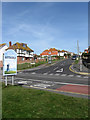
Cranleigh Avenue
Taken from the junction with Marine Drive, the A259. The bus lane in the foreground is a recent innovation that divides the road into three allowing quick access to Brighton from Peacehaven, Saltdean and Rottingdean along the only road that connects these towns. The boundary of Rottingdean and Saltdean is marked by the sign and runs up the east side of Cranleigh Avenue.
Image: © Simon Carey
Taken: 15 Mar 2009
0.02 miles
3
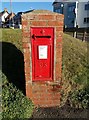
Saltdean: postbox № BN2 155
A GR cipher pillar/wall box located in Saltdean, W.Sx.
Image: © mcc
Taken: 28 Dec 2017
0.03 miles
6

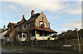
135, Marine Drive, Rottingdean
The house was built sometime in the 1970s on the site of a former sewer ventilation shaft. The shaft was constructed in 1885 and later disguised as a house, see http://regencysociety-jamesgray.com/volume32/source/jg_32_022.htm , and given the number 135. The shaft was capped in the 1950s and the structure eventually demolished in 1973 with the mixed flint and brick wall on the left the only surviving part.
Image: © Simon Carey
Taken: 28 Jan 2016
0.03 miles
7
Little Crescent
The eastern approach to Marine Drive, the A259. As the name suggests it swings round to rejoin the main road to the west.
Image: © Simon Carey
Taken: 15 Mar 2009
0.03 miles
9

Little Crescent, Rottingdean
The road was laid out in the early 1920s as part of the Rottingdean Heights estate. The road is shaped like the letter 'n' and the part of the road in view is the eastern junction with Marine Drive.
Image: © Simon Carey
Taken: 28 Jan 2016
0.04 miles
10
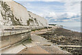
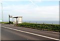
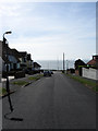
Undercliff Walk
The Undercliff Walk at Rottingdean.
Image: © Ian Capper
Taken: 20 Sep 2022
0.05 miles