IMAGES TAKEN NEAR TO
The Green, BRIGHTON, BN2 7DD
Introduction
This page details the photographs taken nearby to The Green, BN2 7DD by members of the Geograph project.
The Geograph project started in 2005 with the aim of publishing, organising and preserving representative images for every square kilometre of Great Britain, Ireland and the Isle of Man.

There are currently over 7.5m images from over14,400 individuals and you can help contribute to the project by visiting https://www.geograph.org.uk
Image Map
Images are licensed for reuse under creativecommons.org/licenses/by-sa/2.0
Notes
- Clicking on the map will re-center to the selected point.
- The higher the marker number, the further away the image location is from the centre of the postcode.
Image Listing (196 Images Found)
Images are licensed for reuse under creativecommons.org/licenses/by-sa/2.0
Image
Details
Distance
1
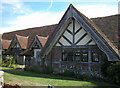
Tudor Close Rottingdean
Originally part of Old Court Farm.
Image: © David Eldridge
Taken: 28 Aug 2006
0.01 miles
2
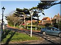
Falmer Road from The Green
At the northern end of Rottingdean Village
Image: © Paul Gillett
Taken: 1 Jan 2010
0.04 miles
3
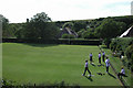
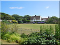
Rottingdean Bowling green
With Rottingdean Windmill on hill
Image: © David Eldridge
Taken: 28 Aug 2006
0.05 miles
5

Challoners Close, Rottingdean
A cul de sac off Dean Court Road that was built in the 1960s.
Image: © Simon Carey
Taken: 28 Jan 2016
0.07 miles
7
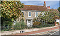
Court House
18th Century house. Grade II* listed - see https://historicengland.org.uk/listing/the-list/list-entry/1381003?section=official-list-entry.
Image: © Ian Capper
Taken: 20 Sep 2022
0.09 miles
8
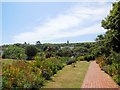
Kipling Gardens
Rottingdean Windmill is in the background
Image: © Paul Gillett
Taken: 4 Jul 2015
0.09 miles
9

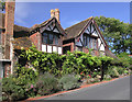
Tudor Cottages, Dean Court Road, Rottingdean
A small terrace of three cottages that were once a tithe barn and adjacent flint cottages belonging to Court Farm. They, along with Tudor Close, were acquired in 1929 by the Saltdean Estate Company who restored them in a 'Tudorbethan' style using materials gathered from other old buildings in the area. Number 1, on the left, was the former barn which possibly dates from 1530. See http://www.rottingdeanvillage.org.uk/wp-content/uploads/2012/12/Page-49-upper.jpg for an original view of the buildings.
Image: © Simon Carey
Taken: 28 Jan 2016
0.09 miles
10
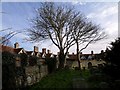
The north side of Rottingdean Churchyard
Image: © tristan forward
Taken: Unknown
0.09 miles