IMAGES TAKEN NEAR TO
Longhill Close, BRIGHTON, BN2 7AX
Introduction
This page details the photographs taken nearby to Longhill Close, BN2 7AX by members of the Geograph project.
The Geograph project started in 2005 with the aim of publishing, organising and preserving representative images for every square kilometre of Great Britain, Ireland and the Isle of Man.

There are currently over 7.5m images from over14,400 individuals and you can help contribute to the project by visiting https://www.geograph.org.uk
Image Map
Images are licensed for reuse under creativecommons.org/licenses/by-sa/2.0
Notes
- Clicking on the map will re-center to the selected point.
- The higher the marker number, the further away the image location is from the centre of the postcode.
Image Listing (23 Images Found)
Images are licensed for reuse under creativecommons.org/licenses/by-sa/2.0
Image
Details
Distance
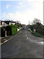
1
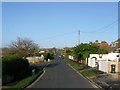
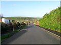
Longhill Road, Ovingdean
Viewed from the southern end where the road turns west and becomes Image with the junction of Image on the left. The road was laid out in the 1920s when Long Hill began to be populated with shacks and bungalows which were replaced after the war by more permanent structures. The highway heads north to a junction with Ovingdean Road on the eastern side of the hill.
Image: © Simon Carey
Taken: 23 Dec 2015
0.07 miles
3
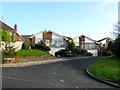
Dower Close, Ovingdean
A cul de sac off Image built in the mid 1960s.
Image: © Simon Carey
Taken: 23 Dec 2015
0.10 miles
4
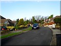
Ainsworth Close, Ovingdean
A cul de sac off Image that was built in the mid 1960s and named after local author Harrison Ainsworth who resided in the village at Ovingdean Granege.
Image: © Simon Carey
Taken: 23 Dec 2015
0.12 miles
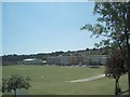
5
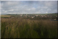
Ovingdean
A view from the surrounding hills
Image: © Kurseong Carl
Taken: 24 Oct 2013
0.13 miles
6
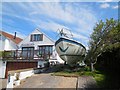
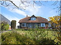
Boat by cottage in Longhill Road
About 1km in land, even global warming will not bring an high tide here any time soon
Image: © Paul Gillett
Taken: 19 Apr 2015
0.15 miles
7
Ainsworth Avenue, Ovingdean
A residential road that runs diagonally down the western side of Long Hill between Image and Greenways. It was laid out in the 1920s following the line of a much older footpath and named after Victorian author Harrison Ainsworth who had resided in the village at Ovingdean Grange. Located on the site of a former field called The South Laine according to Ovingdean's 1839 tithe map. The old centre of the village can be seen in the distance beneath Cattle Hill. See also Image
Image: © Simon Carey
Taken: 23 Dec 2015
0.15 miles
8
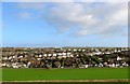
Ovingdean
A view of the modern part of the village that sprang up on Long Hill after 1919 initially as shacks and bungalows which were largely replaced by modern housing after the war. Built on a large former field called The South Laine according to Ovingdean's 1839 tithe map. The field in the foreground is Image, the road beyond Image, that running diagonally up the hill Image, and along the top Image In the distance is High Hill.
Image: © Simon Carey
Taken: 23 Dec 2015
0.16 miles
9
Ainsworth Avenue, Ovingdean
A residential road that runs diagonally down the western side of Long Hill between Image and Greenways. It was laid out in the 1920s following the line of a much older footpath and named after Victorian author Harrison Ainsworth who had resided in the village at Ovingdean Grange. Located on the site of a former field called The South Laine according to Ovingdean's 1839 tithe map. The old centre of the village can be seen in the distance beneath Cattle Hill. See also Image
Image: © Simon Carey
Taken: 23 Dec 2015
0.16 miles
10
Longhill School
Photo shows the school grounds as well as the Deans Leisure Centre (left)
Longhill High School is a specialist technology college, see the schools website: http://www.longhill.brighton-hove.sch.uk/
Image: © Paul Gillett
Taken: 23 Jun 2009
0.16 miles