IMAGES TAKEN NEAR TO
Bodle Street Green, HAILSHAM, BN27 4UD
Introduction
This page details the photographs taken nearby to BN27 4UD by members of the Geograph project.
The Geograph project started in 2005 with the aim of publishing, organising and preserving representative images for every square kilometre of Great Britain, Ireland and the Isle of Man.

There are currently over 7.5m images from over14,400 individuals and you can help contribute to the project by visiting https://www.geograph.org.uk
Image Map
Images are licensed for reuse under creativecommons.org/licenses/by-sa/2.0
Notes
- Clicking on the map will re-center to the selected point.
- The higher the marker number, the further away the image location is from the centre of the postcode.
Image Listing (6 Images Found)
Images are licensed for reuse under creativecommons.org/licenses/by-sa/2.0
Image
Details
Distance
2
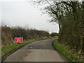
Uneven road surface, Prinkle Lane
Although a good deal less pot-holed than some other lanes in the area, this is the only one seen with this sign. An amateur sign further on suggests this was only put here because of a local's complaint.
Image: © Robin Webster
Taken: 13 Feb 2013
0.06 miles
3
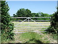
Metal gate, east of Bodle Street Green
Image: © nick macneill
Taken: 3 Jun 2011
0.11 miles
4
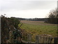
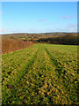
Farmland near Bodle Street Green, East Sussex
Farmland looking south from Prinkle Lane (Bodle Street Green) to Toll Shaw.
Image: © Janet Richardson
Taken: 5 Feb 2006
0.17 miles
5
Footpath to Nowhere
Signposted from Prinkle Lane the footpath takes you to the next square then stops. The trees to the right mark the course of Lower Gill.
Image: © Simon Carey
Taken: 29 Dec 2007
0.22 miles
6
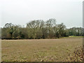
Toll Shaw
This conceals a flooded pit in the Wadhurst Clay, almost certainly dug for iron in former times.
Image: © Robin Webster
Taken: 13 Feb 2013
0.24 miles