IMAGES TAKEN NEAR TO
Middle Way, HAILSHAM, BN27 4TH
Introduction
This page details the photographs taken nearby to Middle Way, BN27 4TH by members of the Geograph project.
The Geograph project started in 2005 with the aim of publishing, organising and preserving representative images for every square kilometre of Great Britain, Ireland and the Isle of Man.

There are currently over 7.5m images from over14,400 individuals and you can help contribute to the project by visiting https://www.geograph.org.uk
Image Map
Images are licensed for reuse under creativecommons.org/licenses/by-sa/2.0
Notes
- Clicking on the map will re-center to the selected point.
- The higher the marker number, the further away the image location is from the centre of the postcode.
Image Listing (47 Images Found)
Images are licensed for reuse under creativecommons.org/licenses/by-sa/2.0
Image
Details
Distance
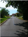
1
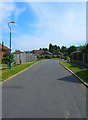
Middle Way
Most of the modern residential area of Windmill Hill is bounded in a triangle of land formed b the A271. Victoria Road and Joes Lane. Taken from the junction with Victoria Road.
Image: © Simon Carey
Taken: 27 Jul 2008
0.02 miles
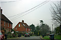
2
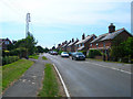
Victoria Road
Many of the houses here date from the last decades of the 19th century hence the name of the road. Prior to that the settlement of Windmill Hill centred around the area known as Posey Green next to the current Horseshoe Inn.
Image: © Simon Carey
Taken: 27 Jul 2008
0.03 miles
3
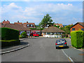
Coombe Close
Small cul-de-sac off Hurst Lane. The houses behind the bungalows are in Victoria Road.
Image: © Simon Carey
Taken: 27 Jul 2008
0.04 miles
4
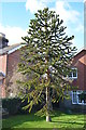
Monkey Puzzle Tree, Victoria Road, Windmill Hill
The owner told me it was about 25 years old. This is the largest of several in this square.
Image: © Julian P Guffogg
Taken: 3 Mar 2013
0.05 miles
5
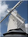
Herstmonceux Windmill Hill
Large restored post mill with 2 storey roundhouse.
Image: © Colin Mitchell
Taken: 16 Aug 2006
0.05 miles
6
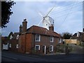
The Mill House at Windmill Hill
It is easy to admire the windmill itself and overlook the associated Mill House which is 18th century Grade II listed with walls of red brick and grey headers, and partly tile hung.
Image: © Nigel Stickells
Taken: 30 Nov 2006
0.05 miles
7
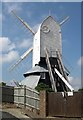
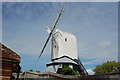
The Windmill at Windmill Hill
The Windmill Hill windmill is a Grade II* Listed Building It is a windmill of the post type and at 48'0", the tallest in Sussex. This mill is the last in England to possess the remains of a centrifugal governor system for controlling the sail area.
It was built around 1814, the mill was last worked by the Harmer family who converted it to steam power in 1893 when the sweeps were removed.
Image: © Stuart Buchan
Taken: 12 May 2007
0.06 miles
9
Victoria Road
Taken from the junction with Joes Lane and looking into the northern end of the hamlet of Windmill Hill. Many of the houses in view were constructed in the last decades of the 19th century hence the name of the road.
Image: © Simon Carey
Taken: 27 Jul 2008
0.08 miles
10
Victoria Road, Windmill Hill
Typical Sussex upper storey tiling on these cottages, although the nearest on the left is entirely brick.
Image: © Robin Webster
Taken: 13 Feb 2013
0.08 miles