IMAGES TAKEN NEAR TO
Victoria Road, HAILSHAM, BN27 4TA
Introduction
This page details the photographs taken nearby to Victoria Road, BN27 4TA by members of the Geograph project.
The Geograph project started in 2005 with the aim of publishing, organising and preserving representative images for every square kilometre of Great Britain, Ireland and the Isle of Man.

There are currently over 7.5m images from over14,400 individuals and you can help contribute to the project by visiting https://www.geograph.org.uk
Image Map
Images are licensed for reuse under creativecommons.org/licenses/by-sa/2.0
Notes
- Clicking on the map will re-center to the selected point.
- The higher the marker number, the further away the image location is from the centre of the postcode.
Image Listing (36 Images Found)
Images are licensed for reuse under creativecommons.org/licenses/by-sa/2.0
Image
Details
Distance
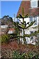
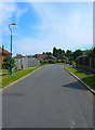
1
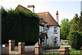
Victoria Road
Many of the houses here date from the last decades of the 19th century hence the name of the road. Prior to that the settlement of Windmill Hill centred around the area known as Posey Green next to the current Horseshoe Inn.
Image: © Simon Carey
Taken: 27 Jul 2008
0.03 miles
2
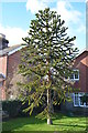
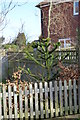
Monkey Puzzle Tree, Victoria Road, Windmill Hill
The owner told me it was about 25 years old. This is the largest of several in this square.
Image: © Julian P Guffogg
Taken: 3 Mar 2013
0.05 miles
3
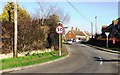
Victoria Road, Windmill Hill, East Sussex
Image: © nick macneill
Taken: 1 Feb 2012
0.06 miles
5
Monkey Puzzle Tree, Monkey Puzzle Close, Windmill Hill
This close was built on the site of the old Monkey Puzzle Garage which was demolished.
Image: © Julian P Guffogg
Taken: 3 Mar 2013
0.07 miles
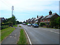
6
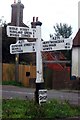
Old Direction Sign - Signpost by the A271, Gardner Street, Windmill Hill
Black iron cap finial - 3 arms; East Sussex wood with number by the A271, in parish of Herstmonceux (Wealden District), Windmill Hill Road, on kerbed weedy triangle at junction of Victoria Road with A271 Windmill Hill Road.
Surveyed
Milestone Society National ID: SX_TQ6412A
Image: © Milestone Society
Taken: Unknown
0.08 miles
7

Cottage at Windmill Hill
On the A271 (Gardner Street)
Image: © Paul Gillett
Taken: 8 Aug 2013
0.08 miles
8
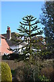
Monkey Puzzle tree, Gardner Street, Windmill Hill
Image: © Julian P Guffogg
Taken: 3 Mar 2013
0.09 miles
9
Middle Way
Most of the modern residential area of Windmill Hill is bounded in a triangle of land formed b the A271. Victoria Road and Joes Lane. Taken from the junction with Victoria Road.
Image: © Simon Carey
Taken: 27 Jul 2008
0.09 miles