IMAGES TAKEN NEAR TO
Bodle Street Green, HAILSHAM, BN27 4QU
Introduction
This page details the photographs taken nearby to BN27 4QU by members of the Geograph project.
The Geograph project started in 2005 with the aim of publishing, organising and preserving representative images for every square kilometre of Great Britain, Ireland and the Isle of Man.

There are currently over 7.5m images from over14,400 individuals and you can help contribute to the project by visiting https://www.geograph.org.uk
Image Map
Images are licensed for reuse under creativecommons.org/licenses/by-sa/2.0
Notes
- Clicking on the map will re-center to the selected point.
- The higher the marker number, the further away the image location is from the centre of the postcode.
Image Listing (24 Images Found)
Images are licensed for reuse under creativecommons.org/licenses/by-sa/2.0
Image
Details
Distance
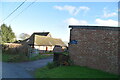
4
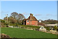
Sandhills Oast, Bodle Street, East Sussex
Image: © Oast House Archive
Taken: 22 Nov 2008
0.07 miles
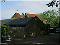
9
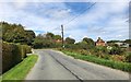
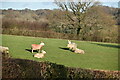
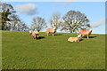
Approaching Sandhills Farm
Heading northwards towards the junction with Sandhill Lane and the two farms.
Image: © Chris Thomas-Atkin
Taken: 9 Sep 2018
0.11 miles
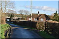
10
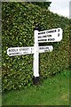
Old Direction Sign - Signpost by Sandhill Lane, Warbleton parish
Black iron cap finial - 3 arms; East Sussex wood by the UC road, in parish of Warbleton (Wealden District), unnamed road, on verge in front of manicured hedge opposite junction with Sandhill Lane.
Surveyed
Milestone Society National ID: SX_TQ6416
Image: © Milestone Society
Taken: Unknown
0.11 miles