IMAGES TAKEN NEAR TO
North Corner, HAILSHAM, BN27 4HJ
Introduction
This page details the photographs taken nearby to North Corner, BN27 4HJ by members of the Geograph project.
The Geograph project started in 2005 with the aim of publishing, organising and preserving representative images for every square kilometre of Great Britain, Ireland and the Isle of Man.

There are currently over 7.5m images from over14,400 individuals and you can help contribute to the project by visiting https://www.geograph.org.uk
Image Map
Images are licensed for reuse under creativecommons.org/licenses/by-sa/2.0
Notes
- Clicking on the map will re-center to the selected point.
- The higher the marker number, the further away the image location is from the centre of the postcode.
Image Listing (12 Images Found)
Images are licensed for reuse under creativecommons.org/licenses/by-sa/2.0
Image
Details
Distance
1
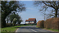
House on the bend
Opposite Lewhurst Farm on the Hailsham - Horam road.
Image: © Robin Webster
Taken: 8 Apr 2007
0.03 miles
2
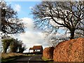
Minor road near Marle Green, East Sussex
Image: © nick macneill
Taken: 4 Dec 2012
0.04 miles

4
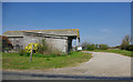
Barns, Lewhurst Farm
On the Hailsham - Horam road.
Image: © Robin Webster
Taken: 8 Apr 2007
0.09 miles

6
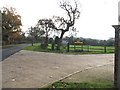
Frost Lane entrance to fencing and timber building manufacturer
Image: © Dave Spicer
Taken: 21 Nov 2010
0.11 miles
7
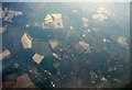
Aerial view of Marle Green area, 2001
Countryside of farmland and woods in the southern Weald, seen from a flight heading to Gatwick from Amsterdam. there's nothing that could be called in village in shot, although Marle Green is right of centre and down a bit.
Image: © Derek Harper
Taken: 17 Apr 2001
0.17 miles
8
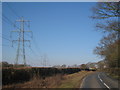
Electricity Pylons off Grove Hill
Near to Lewhurst Farm.
Image: © Oast House Archive
Taken: 7 Mar 2010
0.25 miles
9
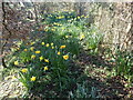
Daffodils near North Corner
These are alongside the track which leads from Grove Hill at North Corner down to the Cuckoo Trail.
Image: © Marathon
Taken: 27 Feb 2022
0.25 miles
10
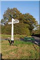
Old Direction Sign - Signpost by Cowden Hall Lane, Horam parish
Black iron cap finial - 3 arms; East Sussex wood by the UC road, in parish of Horam (Wealden District), junction of Cowden Hall Lane with unnamed road, on grass island at junction.
Surveyed
Milestone Society National ID: SX_TQ5915
Image: © Milestone Society
Taken: Unknown
0.25 miles