IMAGES TAKEN NEAR TO
Magnolia Close, HAILSHAM, BN27 4FZ
Introduction
This page details the photographs taken nearby to Magnolia Close, BN27 4FZ by members of the Geograph project.
The Geograph project started in 2005 with the aim of publishing, organising and preserving representative images for every square kilometre of Great Britain, Ireland and the Isle of Man.

There are currently over 7.5m images from over14,400 individuals and you can help contribute to the project by visiting https://www.geograph.org.uk
Image Map
Images are licensed for reuse under creativecommons.org/licenses/by-sa/2.0
Notes
- Clicking on the map will re-center to the selected point.
- The higher the marker number, the further away the image location is from the centre of the postcode.
Image Listing (6 Images Found)
Images are licensed for reuse under creativecommons.org/licenses/by-sa/2.0
Image
Details
Distance
2
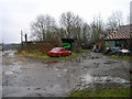
Outbuildings, Park Farm, near Hellingly
Looking east.
Image: © Simon Carey
Taken: 12 Feb 2006
0.12 miles
5
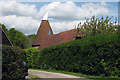
Magham Oast, New Road, Hellingly, East Sussex
Image: © Oast House Archive
Taken: 3 May 2009
0.23 miles
6
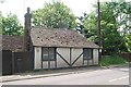
Old Toll House by the A271, Amberstone
Toll House in the parish of Hailsham (Wealden District), Paygate Cottage, Amberstone (A271), North East of Hailsham, BN27 1PQ.
To be surveyed
Milestone Society National ID: ES.HAI
Image: © Milestone Society
Taken: Unknown
0.24 miles