IMAGES TAKEN NEAR TO
Hawthorn Lane, HAILSHAM, BN27 4FU
Introduction
This page details the photographs taken nearby to Hawthorn Lane, BN27 4FU by members of the Geograph project.
The Geograph project started in 2005 with the aim of publishing, organising and preserving representative images for every square kilometre of Great Britain, Ireland and the Isle of Man.

There are currently over 7.5m images from over14,400 individuals and you can help contribute to the project by visiting https://www.geograph.org.uk
Image Map
Images are licensed for reuse under creativecommons.org/licenses/by-sa/2.0
Notes
- Clicking on the map will re-center to the selected point.
- The higher the marker number, the further away the image location is from the centre of the postcode.
Image Listing (11 Images Found)
Images are licensed for reuse under creativecommons.org/licenses/by-sa/2.0
Image
Details
Distance
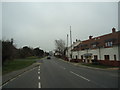
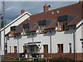
4
New housing on Hailsham Road
Along the A271 through Herstmonceux.
Image: © Oast House Archive
Taken: 19 Jul 2011
0.15 miles
5
New housing on Hailsham Road
Along the A271 through Herstmonceux.
Image: © Oast House Archive
Taken: 19 Jul 2011
0.15 miles
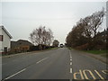
6
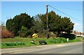
Bench and telegraph pole, Herstmonceux
Image: © nick macneill
Taken: 1 Apr 2013
0.18 miles
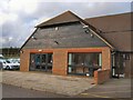
7
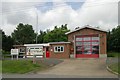
Herstmonceux fire station
Herstmonceux fire station, Hailsham Road, Herstmonceux, East Sussex
Image: © Kevin Hale
Taken: 16 Jun 2007
0.21 miles
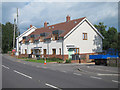
8
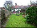
Bedlam Cottages, Herstmonceux
As the name suggests these old cottages were the former lunatic asylum for the parish. This view looks south from West End.
Image: © Simon Carey
Taken: 12 Feb 2006
0.21 miles
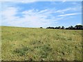
10
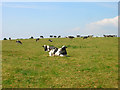
Cows on the Hill
Belonging to nearby Lime End Farm in the field that has the footpath from Butler's Lane to Herstmonceux running through it.
Image: © Simon Carey
Taken: 27 Jul 2008
0.23 miles