IMAGES TAKEN NEAR TO
Honeysuckle Avenue, HAILSHAM, BN27 4FP
Introduction
This page details the photographs taken nearby to Honeysuckle Avenue, BN27 4FP by members of the Geograph project.
The Geograph project started in 2005 with the aim of publishing, organising and preserving representative images for every square kilometre of Great Britain, Ireland and the Isle of Man.

There are currently over 7.5m images from over14,400 individuals and you can help contribute to the project by visiting https://www.geograph.org.uk
Image Map
Images are licensed for reuse under creativecommons.org/licenses/by-sa/2.0
Notes
- Clicking on the map will re-center to the selected point.
- The higher the marker number, the further away the image location is from the centre of the postcode.
Image Listing (13 Images Found)
Images are licensed for reuse under creativecommons.org/licenses/by-sa/2.0
Image
Details
Distance
3
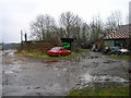
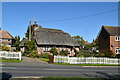
Outbuildings, Park Farm, near Hellingly
Looking east.
Image: © Simon Carey
Taken: 12 Feb 2006
0.16 miles
4
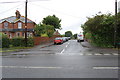
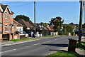
A271 - A293 junction
The A293 turns left to the centre of Hailsham and beyond towards Eastbourne (but they don't tell you that). The A271 continues, signed to Eastbourne and Lewes (via the A22).
Image: © Robin Webster
Taken: 15 Nov 2011
0.18 miles

10
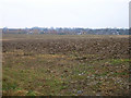
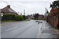
Crossing the muddy field to Hailsham
Looking south from New Road towards the northern fringes of Hailsham.
Image: © Simon Carey
Taken: 12 Feb 2006
0.23 miles