IMAGES TAKEN NEAR TO
Iris Close, HAILSHAM, BN27 4FD
Introduction
This page details the photographs taken nearby to Iris Close, BN27 4FD by members of the Geograph project.
The Geograph project started in 2005 with the aim of publishing, organising and preserving representative images for every square kilometre of Great Britain, Ireland and the Isle of Man.

There are currently over 7.5m images from over14,400 individuals and you can help contribute to the project by visiting https://www.geograph.org.uk
Image Map
Images are licensed for reuse under creativecommons.org/licenses/by-sa/2.0
Notes
- Clicking on the map will re-center to the selected point.
- The higher the marker number, the further away the image location is from the centre of the postcode.
Image Listing (13 Images Found)
Images are licensed for reuse under creativecommons.org/licenses/by-sa/2.0
Image
Details
Distance

8
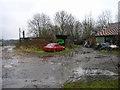
Outbuildings, Park Farm, near Hellingly
Looking east.
Image: © Simon Carey
Taken: 12 Feb 2006
0.20 miles
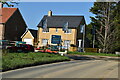
10
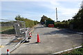
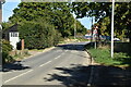
New Road now Old Road
The western end of New Road has been abandoned for a real new road a few hundred metres to the north (not shown on map at this time).
Image: © Julian P Guffogg
Taken: 9 Oct 2011
0.22 miles