IMAGES TAKEN NEAR TO
Danecroft Place, HAILSHAM, BN27 4ES
Introduction
This page details the photographs taken nearby to Danecroft Place, BN27 4ES by members of the Geograph project.
The Geograph project started in 2005 with the aim of publishing, organising and preserving representative images for every square kilometre of Great Britain, Ireland and the Isle of Man.

There are currently over 7.5m images from over14,400 individuals and you can help contribute to the project by visiting https://www.geograph.org.uk
Image Map (Loading...)


Getting Data...Please wait
Leaflet Map data © OpenStreetMap
Images are licensed for reuse under creativecommons.org/licenses/by-sa/2.0
Notes
- Clicking on the map will re-center to the selected point.
- The higher the marker number, the further away the image location is from the centre of the postcode.
Image Listing (64 Images Found)
Images are licensed for reuse under creativecommons.org/licenses/by-sa/2.0
Image
Details
Distance
1

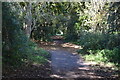
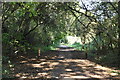
Old Nursery and Railway Bridge, Hellingly
The bridge in the foreground used to span the railway but this was a victim of the Beeching cuts of the 1960s; it now crosses a footpath known as the Cuckoo Line.
Image: © Kevin Gordon
Taken: 16 Oct 2008
0.05 miles

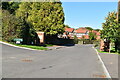
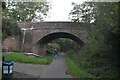
10
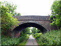
Station Road Bridge, Hellingly
The bridge carries Station Road over the old railway line now The Cuckoo Trail
Image: © PAUL FARMER
Taken: 14 Jun 2014
0.09 miles