IMAGES TAKEN NEAR TO
North Street, HAILSHAM, BN27 4DU
Introduction
This page details the photographs taken nearby to North Street, BN27 4DU by members of the Geograph project.
The Geograph project started in 2005 with the aim of publishing, organising and preserving representative images for every square kilometre of Great Britain, Ireland and the Isle of Man.

There are currently over 7.5m images from over14,400 individuals and you can help contribute to the project by visiting https://www.geograph.org.uk
Image Map
Images are licensed for reuse under creativecommons.org/licenses/by-sa/2.0
Notes
- Clicking on the map will re-center to the selected point.
- The higher the marker number, the further away the image location is from the centre of the postcode.
Image Listing (47 Images Found)
Images are licensed for reuse under creativecommons.org/licenses/by-sa/2.0
Image
Details
Distance
1
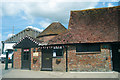
Oast, Broad Farm, Hellingly, East Sussex
Single round kiln. Possibly formerly one of a pair. Kiln roof replaced with lower conical roof. Now used as offices at the farm.
Image: © Oast House Archive
Taken: 3 May 2009
0.02 miles
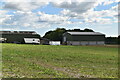
2
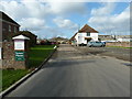
The Granary Rural Business Centre
Next to Broad Farm.
Image: © Dave Spicer
Taken: 27 Nov 2011
0.02 miles
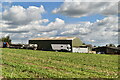
3
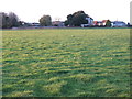
Broad Farm
From the footpath to Hellingly.
Image: © Dave Spicer
Taken: 27 Nov 2011
0.04 miles
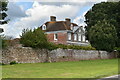
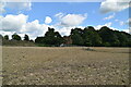
5
House at Broad Farm on the A267
The large tree at the entrance is an Holm Oak.
Image: © Dave Spicer
Taken: 27 Nov 2011
0.05 miles
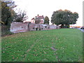
7
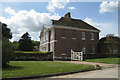
Broad Farmhouse, North Street, Hellingly
Grade II* Listed.
Image: © Oast House Archive
Taken: 3 May 2009
0.06 miles