IMAGES TAKEN NEAR TO
Lower Dicker, HAILSHAM, BN27 4BZ
Introduction
This page details the photographs taken nearby to BN27 4BZ by members of the Geograph project.
The Geograph project started in 2005 with the aim of publishing, organising and preserving representative images for every square kilometre of Great Britain, Ireland and the Isle of Man.

There are currently over 7.5m images from over14,400 individuals and you can help contribute to the project by visiting https://www.geograph.org.uk
Image Map
Images are licensed for reuse under creativecommons.org/licenses/by-sa/2.0
Notes
- Clicking on the map will re-center to the selected point.
- The higher the marker number, the further away the image location is from the centre of the postcode.
Image Listing (46 Images Found)
Images are licensed for reuse under creativecommons.org/licenses/by-sa/2.0
Image
Details
Distance
1
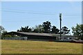
Northfields Business Park
Small set of business units next to the A22 at Lower Dicker.
Image: © Simon Carey
Taken: 26 Feb 2012
0.02 miles
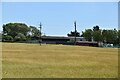
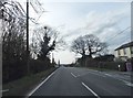
2
Business Park on the A22 at Lower Dicker
Image: © Dave Spicer
Taken: 5 Aug 2012
0.04 miles
3
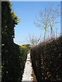
Footpath, The Dicker
Linking the A22 to a green lane to the south and made when the former Dicker Common was enclosed in 1813. This section lies between steep hedges.
Image: © Simon Carey
Taken: 11 Feb 2012
0.06 miles
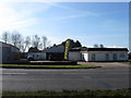
4
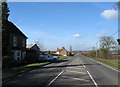
The Dicker
The name of the A22 between the junction with Nash Street and the Boship Roundabout which derives from its original route through Dicker Common which was enclosed in 1815. That enclosure resulted in the straightening of the road and the straggling nature of the residences and businesses which lay either side of it. The house on the left is Northfields with Image beyond it and Mill Cottage further on.
Image: © Simon Carey
Taken: 26 Feb 2012
0.06 miles
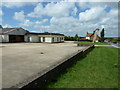
6
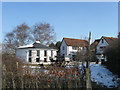
Old Dicker Mill
Now its old but when built it was known as Dicker New Mill to distinguish it from Image found a mile or so to the west at Golden Cross. Not marked on Yeakell & Gardner's map of 1778-83 but is on the OS survey published in 1813 so built before the enclosure of the common in the same year. The roundhouse is all that remains of the former post mill.
Image: © Simon Carey
Taken: 11 Feb 2012
0.08 miles
7
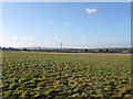
Former Dicker Common
An unnamed field in Chiddingly's 1839 tithe map, it was once part of a large common that was enclosed in 1813. This view looks south west with the South Downs on the horizon.
Image: © Simon Carey
Taken: 15 Jan 2012
0.08 miles
8
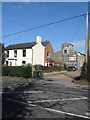
Prospect House, Lower Dicker
Located on the junction of the A22 and the private road to Image The original house dates from the 19th century but I have a feeling it is now used , or at the very least the rear is used, as a number of small offices or business units.
Image: © Simon Carey
Taken: 26 Feb 2012
0.09 miles