IMAGES TAKEN NEAR TO
Lower Dicker, HAILSHAM, BN27 4BH
Introduction
This page details the photographs taken nearby to BN27 4BH by members of the Geograph project.
The Geograph project started in 2005 with the aim of publishing, organising and preserving representative images for every square kilometre of Great Britain, Ireland and the Isle of Man.

There are currently over 7.5m images from over14,400 individuals and you can help contribute to the project by visiting https://www.geograph.org.uk
Image Map
Images are licensed for reuse under creativecommons.org/licenses/by-sa/2.0
Notes
- Clicking on the map will re-center to the selected point.
- The higher the marker number, the further away the image location is from the centre of the postcode.
Image Listing (11 Images Found)
Images are licensed for reuse under creativecommons.org/licenses/by-sa/2.0
Image
Details
Distance
4
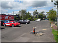
Garden Centre Car Park
A rare 1950's red Corvette to the left.
Image: © Oast House Archive
Taken: 2 Aug 2009
0.12 miles
5

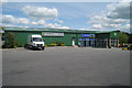
Giant Santa, Wyevale Garden Centre
A rather large inflatable in the car park welcoming all and sundry to the garden centre.
Image: © Simon Carey
Taken: 2 Dec 2012
0.13 miles
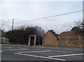
7
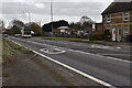
A22 at Lower Dicker looking east south-east
Image: © Patrick Roper
Taken: 17 Aug 2006
0.14 miles
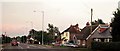
9
The Croft, Lower Dicker
Lying alongside the A22 is this set of semi-detached cottages built in the 1890s.
Image: © Simon Carey
Taken: 26 Feb 2012
0.20 miles
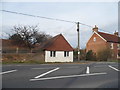
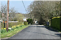
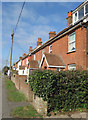
10
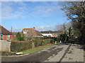
Hackhurst Lane, Lower Dicker
Small road leading to Image then beyond to Image and Perrylands Farm. Its straightness is due to being formed out of the enclosure of Dicker Common back in 1813. The houses on the left were built during the interwar years.
Image: © Simon Carey
Taken: 26 Feb 2012
0.21 miles