IMAGES TAKEN NEAR TO
Golden Cross, HAILSHAM, BN27 4AN
Introduction
This page details the photographs taken nearby to Golden Cross, BN27 4AN by members of the Geograph project.
The Geograph project started in 2005 with the aim of publishing, organising and preserving representative images for every square kilometre of Great Britain, Ireland and the Isle of Man.

There are currently over 7.5m images from over14,400 individuals and you can help contribute to the project by visiting https://www.geograph.org.uk
Image Map
Images are licensed for reuse under creativecommons.org/licenses/by-sa/2.0
Notes
- Clicking on the map will re-center to the selected point.
- The higher the marker number, the further away the image location is from the centre of the postcode.
Image Listing (64 Images Found)
Images are licensed for reuse under creativecommons.org/licenses/by-sa/2.0
Image
Details
Distance
3
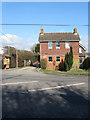
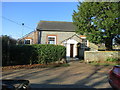
Chapel House, Golden Cross
Located on the A22 next to the small drive that leads to Golden Cross Chapel, a small baptist chapel, that has been located here since the 1839 tithe map at least. The drive is also part of a public footpath that heads north to Burgh Hill Road.
Image: © Simon Carey
Taken: 26 Feb 2012
0.05 miles
4

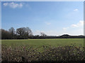
North Field
The name of the field according to Chiddingly's 1839 tithe map that were formed when the old Dicker Common was enclosed in 1813.
Image: © Simon Carey
Taken: 26 Feb 2012
0.06 miles
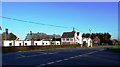
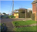
7
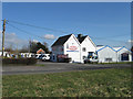
Marquis Motorhomes, Golden Cross
Previously a corn mill and seed depot now home to a business selling motor homes.
Image: © Simon Carey
Taken: 26 Feb 2012
0.06 miles
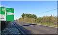
8
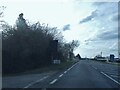
The A22, Golden Cross
The little sign has gone since I took this. It has a Sussex county shield on it.
Image: © David Howard
Taken: 3 Apr 2016
0.07 miles
9
Well Field
The name of the field according to Chiddingly's 1839 tithe map with Oakfield Farm beyond the eastern end of the field. The field was made during the enclosure of the old Dicker Common in 1813.
Image: © Simon Carey
Taken: 26 Feb 2012
0.08 miles