IMAGES TAKEN NEAR TO
Coldharbour Road, HAILSHAM, BN27 3PZ
Introduction
This page details the photographs taken nearby to Coldharbour Road, BN27 3PZ by members of the Geograph project.
The Geograph project started in 2005 with the aim of publishing, organising and preserving representative images for every square kilometre of Great Britain, Ireland and the Isle of Man.

There are currently over 7.5m images from over14,400 individuals and you can help contribute to the project by visiting https://www.geograph.org.uk
Image Map
Images are licensed for reuse under creativecommons.org/licenses/by-sa/2.0
Notes
- Clicking on the map will re-center to the selected point.
- The higher the marker number, the further away the image location is from the centre of the postcode.
Image Listing (5 Images Found)
Images are licensed for reuse under creativecommons.org/licenses/by-sa/2.0
Image
Details
Distance
1
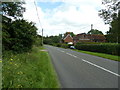
Coldharbour Road passing Pages Mill
The first house on the right is Pages Mill.
Image: © Dave Spicer
Taken: 5 Aug 2012
0.05 miles
2
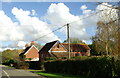
Plenties Farm, Upper Dicker, East Sussex
Image: © nick macneill
Taken: 14 Oct 2011
0.07 miles
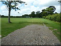
5
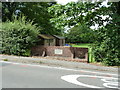
Coronation plaque on brick wall by Upper Dicker playing field
The inscription is 'King George VI Queen Elizabeth crowned May 12th 1937.
Image: © Dave Spicer
Taken: 5 Aug 2012
0.24 miles