IMAGES TAKEN NEAR TO
Coldharbour Road, HAILSHAM, BN27 3PX
Introduction
This page details the photographs taken nearby to Coldharbour Road, BN27 3PX by members of the Geograph project.
The Geograph project started in 2005 with the aim of publishing, organising and preserving representative images for every square kilometre of Great Britain, Ireland and the Isle of Man.

There are currently over 7.5m images from over14,400 individuals and you can help contribute to the project by visiting https://www.geograph.org.uk
Image Map
Images are licensed for reuse under creativecommons.org/licenses/by-sa/2.0
Notes
- Clicking on the map will re-center to the selected point.
- The higher the marker number, the further away the image location is from the centre of the postcode.
Image Listing (9 Images Found)
Images are licensed for reuse under creativecommons.org/licenses/by-sa/2.0
Image
Details
Distance
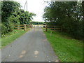
1

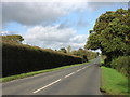
Coldharbour Road
By the drive to Field House.
Image: © Robin Webster
Taken: 21 Apr 2012
0.05 miles
4
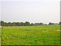
Farmland, Coldharbour Road
Looking east north east from Coldharbour Road near The Nurseries at a field of llamas.
Image: © Simon Carey
Taken: 8 Oct 2005
0.08 miles
5
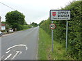
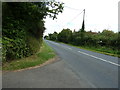
Approaching Upper Dicker, Coldharbour Road
Image: © Richard Cooke
Taken: 4 Jun 2018
0.08 miles
6
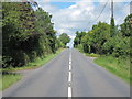
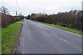
Coldharbour Road
Road from Upper Dicker to the A22.
Image: © Oast House Archive
Taken: 7 Jun 2011
0.08 miles
8
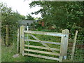
Footpath gate to poultry farm by Field House
Image: © Dave Spicer
Taken: 5 Aug 2012
0.20 miles