IMAGES TAKEN NEAR TO
Ersham Road, HAILSHAM, BN27 3LB
Introduction
This page details the photographs taken nearby to Ersham Road, BN27 3LB by members of the Geograph project.
The Geograph project started in 2005 with the aim of publishing, organising and preserving representative images for every square kilometre of Great Britain, Ireland and the Isle of Man.

There are currently over 7.5m images from over14,400 individuals and you can help contribute to the project by visiting https://www.geograph.org.uk
Image Map
Images are licensed for reuse under creativecommons.org/licenses/by-sa/2.0
Notes
- Clicking on the map will re-center to the selected point.
- The higher the marker number, the further away the image location is from the centre of the postcode.
Image Listing (68 Images Found)
Images are licensed for reuse under creativecommons.org/licenses/by-sa/2.0
Image
Details
Distance
4
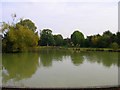
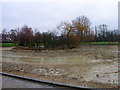
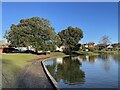
Hailsham Common Pond
What used to be a pond on a common is now part of a park within the small town of Hailsham. This view looks east.
Image: © Simon Carey
Taken: 8 Oct 2005
0.17 miles
5
Hailsham Common Pond
Currently drained. Compare with Image]
Image: © Simon Carey
Taken: 12 Feb 2006
0.17 miles
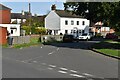
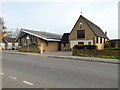
7
Hailsham Free Church, Western Road, Hailsham
Taken from the site of the former railway looking north.
Image: © Simon Carey
Taken: 8 Oct 2005
0.17 miles
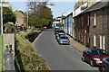
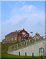
8
Terraced houses on Station Road
The road originally served Hailsham railway station (the site, to the left of the photo, is now a car park).
Image: © Stephen Craven
Taken: 10 Nov 2012
0.17 miles
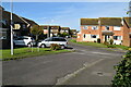
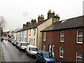
10
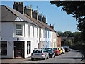
Station Road
A colourful row of terraced houses and business unit. The road is near the old railway station and runs parallel to the former railway which is now the Cuckoo line recreational trail.
Image: © Oast House Archive
Taken: 19 Jul 2011
0.18 miles