IMAGES TAKEN NEAR TO
South Road, HAILSHAM, BN27 3JG
Introduction
This page details the photographs taken nearby to South Road, BN27 3JG by members of the Geograph project.
The Geograph project started in 2005 with the aim of publishing, organising and preserving representative images for every square kilometre of Great Britain, Ireland and the Isle of Man.

There are currently over 7.5m images from over14,400 individuals and you can help contribute to the project by visiting https://www.geograph.org.uk
Image Map
Images are licensed for reuse under creativecommons.org/licenses/by-sa/2.0
Notes
- Clicking on the map will re-center to the selected point.
- The higher the marker number, the further away the image location is from the centre of the postcode.
Image Listing (92 Images Found)
Images are licensed for reuse under creativecommons.org/licenses/by-sa/2.0
Image
Details
Distance
2
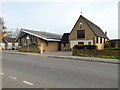
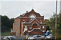
Hailsham Free Church, Western Road, Hailsham
Taken from the site of the former railway looking north.
Image: © Simon Carey
Taken: 8 Oct 2005
0.10 miles
3
Hailsham: site of former station and course of railway, 1993
View southward from A295, towards Polegate and Eastbourne: ex-LB&SCR London/Tunbridge Wells West - Eridge - Polegate - Eastbourne line. The line from Eridge was closed 14/6/65, but Hailsham station and the line to Polegate survived until 9/9/68. Nothing to be seen 25 years later.
Image: © Ben Brooksbank
Taken: 24 Mar 1993
0.13 miles
4
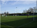
The Beaconsfield - Hailsham Town Football Club
This picture is taken on the Boxing Day local derby between Hailsham Town (yellow) and Eastbourne United (sky blue change kit). United won! The stand seen is the only stand in the ground. The ground adjoins a local park where Hailsham Cricket Club play.
Image: © nick macneill
Taken: 26 Dec 2007
0.13 miles
7
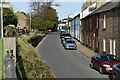
Terraced houses on Station Road
The road originally served Hailsham railway station (the site, to the left of the photo, is now a car park).
Image: © Stephen Craven
Taken: 10 Nov 2012
0.14 miles
8
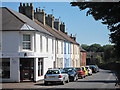
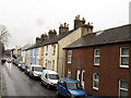
Station Road
A colourful row of terraced houses and business unit. The road is near the old railway station and runs parallel to the former railway which is now the Cuckoo line recreational trail.
Image: © Oast House Archive
Taken: 19 Jul 2011
0.14 miles
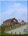
10

South Road Bridge, The Cuckoo Trail, Hailsham
Image: © PAUL FARMER
Taken: 6 Jun 2018
0.14 miles