IMAGES TAKEN NEAR TO
Telford Lane, HAILSHAM, BN27 3GJ
Introduction
This page details the photographs taken nearby to Telford Lane, BN27 3GJ by members of the Geograph project.
The Geograph project started in 2005 with the aim of publishing, organising and preserving representative images for every square kilometre of Great Britain, Ireland and the Isle of Man.

There are currently over 7.5m images from over14,400 individuals and you can help contribute to the project by visiting https://www.geograph.org.uk
Image Map
Images are licensed for reuse under creativecommons.org/licenses/by-sa/2.0
Notes
- Clicking on the map will re-center to the selected point.
- The higher the marker number, the further away the image location is from the centre of the postcode.
Image Listing (6 Images Found)
Images are licensed for reuse under creativecommons.org/licenses/by-sa/2.0
Image
Details
Distance
1
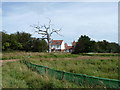
Dead tree new house
By the new housing estate.
Image: © Dave Spicer
Taken: 5 Aug 2012
0.11 miles
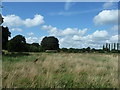
4

The redirected Wealdway
Due to the housing estate construction the path is bordered by the fencing and the A22. Within a 100 yards the path is blocked by the safety fence.
Image: © Dave Spicer
Taken: 5 Aug 2012
0.21 miles
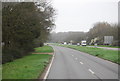
6
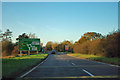
A22 approaching the Boship Roundabout
The dual carriageway finishes at the roundabout and does not reappear on the A22 for a very long way - until north of the A25.
Image: © Robin Webster
Taken: 17 Nov 2011
0.22 miles