IMAGES TAKEN NEAR TO
Woodpecker Drive, HAILSHAM, BN27 3EZ
Introduction
This page details the photographs taken nearby to Woodpecker Drive, BN27 3EZ by members of the Geograph project.
The Geograph project started in 2005 with the aim of publishing, organising and preserving representative images for every square kilometre of Great Britain, Ireland and the Isle of Man.

There are currently over 7.5m images from over14,400 individuals and you can help contribute to the project by visiting https://www.geograph.org.uk
Image Map
Images are licensed for reuse under creativecommons.org/licenses/by-sa/2.0
Notes
- Clicking on the map will re-center to the selected point.
- The higher the marker number, the further away the image location is from the centre of the postcode.
Image Listing (22 Images Found)
Images are licensed for reuse under creativecommons.org/licenses/by-sa/2.0
Image
Details
Distance
1
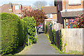
Twitten or footpath
Twitten from Beuzeville Avenue between the houses to Summerheath Road (B2104)
Image: © Edintheclouds
Taken: 15 Apr 2017
0.15 miles
2
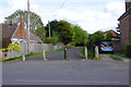
View from Summerfields Avenue
I understand this was an entrance to a Rope manufacturing factory, it's now an access road for emergency vehicles. The centre bollard can be removed at both ends for access to new housing estate.
Image: © Edintheclouds
Taken: 15 Apr 2017
0.16 miles
3
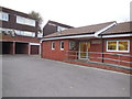
Diplocks Hall, Hailsham
The Diplocks Community Trust was set up in 2001, its key objective being to build a Community Hall for The Diplocks housing estate in Hailsham http://www.diplockshall.org.uk/history.php
Image: © Paul Gillett
Taken: 27 Oct 2015
0.17 miles
4
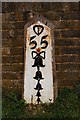
Old Milepost by the B2104, Leaps Cross, Hailsham parish
Metal plate attached to wooden post by the B2104 (was A22), in parish of HAILSHAM (WEALDEN District), Leaps Cross, by old ambulance station, opposite junction with Summerfields Avenue, on lawn with back to low brick wall, on East side of road. Bow Bells and Buckle iron plate, erected by the Horsebridge & Horeham turnpike trust in the 19th century.
Inscription reads:-
{Pelham Buckle}
55
{Bow and 4 Bells}
East Sussex HER.
HER Ref: MES21817 https://www.heritagegateway.org.uk/Gateway/Results_Single.aspx?uid=MES21817&resourceID=1026
Milestone Society National ID: SX_LLE55.
Image: © Keith Sharp
Taken: 15 Apr 2015
0.21 miles
5
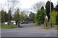
Entrance to ambulance station
Entrance to the Hailsham ambulance station on the B2104 London Road, the ambulance station is now closed having been moved out of Hailsham town.
The main building can be seen on Image
Image: © Edintheclouds
Taken: 15 Apr 2017
0.22 miles

8
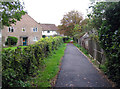
Footpath towards Western Road
The footpath crosses the Cuckoo Trail on the way from High Street to Western Road. The houses to the left are on Downsview Way.
Image: © Andrew Tatlow
Taken: 22 Oct 2015
0.23 miles
9
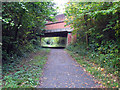
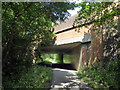
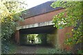
Cuckoo Trail passes beneath London Road
Image: © Andrew Tatlow
Taken: 22 Oct 2015
0.23 miles