IMAGES TAKEN NEAR TO
Western Road, HAILSHAM, BN27 3DQ
Introduction
This page details the photographs taken nearby to Western Road, BN27 3DQ by members of the Geograph project.
The Geograph project started in 2005 with the aim of publishing, organising and preserving representative images for every square kilometre of Great Britain, Ireland and the Isle of Man.

There are currently over 7.5m images from over14,400 individuals and you can help contribute to the project by visiting https://www.geograph.org.uk
Image Map
Images are licensed for reuse under creativecommons.org/licenses/by-sa/2.0
Notes
- Clicking on the map will re-center to the selected point.
- The higher the marker number, the further away the image location is from the centre of the postcode.
Image Listing (186 Images Found)
Images are licensed for reuse under creativecommons.org/licenses/by-sa/2.0
Image
Details
Distance
3
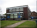
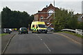
Hailsham Library May 14th 2005
Photographed on May 14th 2005 before a major re-fit to include a lift.
Image: © David Harvey
Taken: 14 May 2005
0.03 miles
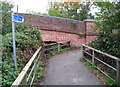
8

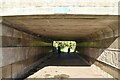
South Road Bridge, The Cuckoo Trail, Hailsham
Image: © PAUL FARMER
Taken: 6 Jun 2018
0.06 miles
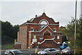
9
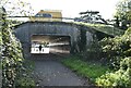
Former Drill Hall, Sturton Place
Image: © Oast House Archive
Taken: 22 Oct 2016
0.06 miles
10
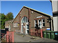
Path from the Cuckoo Trail to the town centre
Image: © Andrew Tatlow
Taken: 22 Oct 2015
0.06 miles