IMAGES TAKEN NEAR TO
White Dyke, HAILSHAM, BN27 2SD
Introduction
This page details the photographs taken nearby to White Dyke, BN27 2SD by members of the Geograph project.
The Geograph project started in 2005 with the aim of publishing, organising and preserving representative images for every square kilometre of Great Britain, Ireland and the Isle of Man.

There are currently over 7.5m images from over14,400 individuals and you can help contribute to the project by visiting https://www.geograph.org.uk
Image Map
Images are licensed for reuse under creativecommons.org/licenses/by-sa/2.0
Notes
- Clicking on the map will re-center to the selected point.
- The higher the marker number, the further away the image location is from the centre of the postcode.
Image Listing (33 Images Found)
Images are licensed for reuse under creativecommons.org/licenses/by-sa/2.0
Image
Details
Distance
2
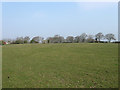
Great Field
The name of the field according to the 1844 tithe map. Trees and hedgerows have now taken the place of ditches and sewers.
Image: © Simon Carey
Taken: 15 Apr 2010
0.05 miles
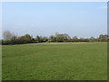
3
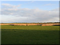
Three Acre Marsh
The name of the field according to the 1844 tithe map and part of Down Level. The field is catching the late evening sun.
Image: © Simon Carey
Taken: 3 May 2010
0.05 miles
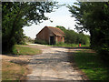
4
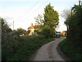
White Dyke Farm
Viewed from the end of White Dyke Road after which the lane becomes a restricted byway across the marshes to Horse Eye.
Image: © Simon Carey
Taken: 3 May 2010
0.06 miles
5
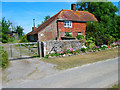
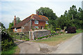
Old Farm, White Dyke
Marked on the A to Z county atlas as Lookers Cottage which seems to suggest a past involvement in the smuggling trade which was rife in this area during the eighteenth and nineteenth centuries.
Image: © Simon Carey
Taken: 16 Jul 2006
0.06 miles
6
Six Acre Marsh
The name of the field according to the 1844 tithe map and part of Down Level.
Image: © Simon Carey
Taken: 3 May 2010
0.06 miles
8
Lower Field
The name of the field according to the 1844 tithe map. It also carries the footpath from Snapson's Drove to Howard Close.
Image: © Simon Carey
Taken: 15 Apr 2010
0.08 miles
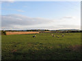
9
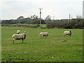
Sheep in field
South of the lane called White Dyke, although mapped as Mill Road.
Image: © Robin Webster
Taken: 11 Mar 2012
0.10 miles
10
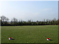
Doctors Field
The name of the field according to the 1844 tithe map. The two tubs contained sheep feed.
Image: © Simon Carey
Taken: 15 Apr 2010
0.11 miles