IMAGES TAKEN NEAR TO
Station Road, HAILSHAM, BN27 2SB
Introduction
This page details the photographs taken nearby to Station Road, BN27 2SB by members of the Geograph project.
The Geograph project started in 2005 with the aim of publishing, organising and preserving representative images for every square kilometre of Great Britain, Ireland and the Isle of Man.

There are currently over 7.5m images from over14,400 individuals and you can help contribute to the project by visiting https://www.geograph.org.uk
Image Map
Images are licensed for reuse under creativecommons.org/licenses/by-sa/2.0
Notes
- Clicking on the map will re-center to the selected point.
- The higher the marker number, the further away the image location is from the centre of the postcode.
Image Listing (11 Images Found)
Images are licensed for reuse under creativecommons.org/licenses/by-sa/2.0
Image
Details
Distance
1
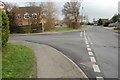
Junction of Swan Road with Station Road, Hailsham
Image: © Julian P Guffogg
Taken: 29 Jan 2012
0.11 miles
2
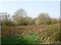
Lower Gate Field
The name of the field according to the 1844 tithe map. Being on the outskirts of Hailsham and backed onto by housing estates the field has been taken out of agricultural use and lost to scrub though a horse was wandering about here. Judging by the discarded rubbish and cycle tracks in the mud I'd imagine the local youth use it quite regularly.
Image: © Simon Carey
Taken: 15 Apr 2010
0.14 miles
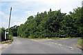
3
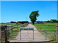
New Barn Farm near Hailsham
This square is part agricultural, part urban. As you travel north you enter Hailsham, how long before Hailsham gets to here?
Image: © Simon Carey
Taken: 16 Jul 2006
0.14 miles
4
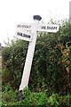
Old Direction Sign - Signpost by Station Road, Hailsham
Black iron cap finial - 3 arms; East Sussex wood by the UC road, in parish of Hailsham (Wealden District), junction of Old Swan Lane with Station Road, grass verge.
Surveyed
Milestone Society National ID: SX_TQ5908
Image: © Milestone Society
Taken: Unknown
0.14 miles
5
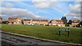
Green by Pelham Crescent, Hailsham
Viewed from Archery Walk
Image: © Paul Gillett
Taken: 18 Feb 2015
0.14 miles
7
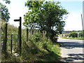
Footpath Hailsham 45 off Old Swan Lane
The T junction ahead is with Station Road.
Image: © Dave Spicer
Taken: 20 Aug 2013
0.15 miles
8
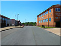
Station Road Industrial Estate, Hailsham
Entrance to a small industrial estate on the outskirts of Hailsham. The building to the right is Wightman & Parrish, purveyor of healthcare and hygiene supplies.
Image: © Simon Carey
Taken: 16 Jul 2006
0.17 miles
9

Howard Close
Small cul-de-sac off Swan Road built in the 1970s.
Image: © Simon Carey
Taken: 15 Apr 2010
0.22 miles
10

Upper Stumbles
The name of the field according to the 1844 tithe map. The buildings on the extreme right mark the site of Hamlin's windmill a smock mill that was built in 1834 and burnt down in a fire in 1923. The shell was then fitted out as a power mill but that too burnt down in another fire in 1967 and only the ancillary buildings now remain.
Image: © Simon Carey
Taken: 15 Apr 2010
0.22 miles