IMAGES TAKEN NEAR TO
Downash, HAILSHAM, BN27 2RP
Introduction
This page details the photographs taken nearby to BN27 2RP by members of the Geograph project.
The Geograph project started in 2005 with the aim of publishing, organising and preserving representative images for every square kilometre of Great Britain, Ireland and the Isle of Man.

There are currently over 7.5m images from over14,400 individuals and you can help contribute to the project by visiting https://www.geograph.org.uk
Image Map
Images are licensed for reuse under creativecommons.org/licenses/by-sa/2.0
Notes
- Clicking on the map will re-center to the selected point.
- The higher the marker number, the further away the image location is from the centre of the postcode.
Image Listing (25 Images Found)
Images are licensed for reuse under creativecommons.org/licenses/by-sa/2.0
Image
Details
Distance
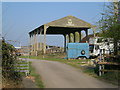
1
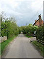
Gassons Farm
On Rickney Lane opposite Slyes Farm Cottages which are out of shot to the left.
Image: © Simon Carey
Taken: 3 May 2010
0.00 miles
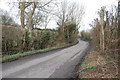
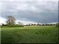
2
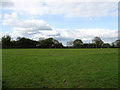
Banky Piece
The name of the field according to the 1844 tithe map viewed from Rickney Lane.
Image: © Simon Carey
Taken: 3 May 2010
0.06 miles
3
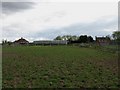
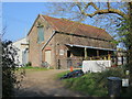
Slyes Farm
The farmhouse is on the right whilst Slyes Farm Cottages are to the left. The footpath from Old Swan Lane goes through the barns in the centre though I found the farm gate padlocked at the entrance to Rickney Lane.
Image: © Simon Carey
Taken: 3 May 2010
0.07 miles
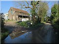
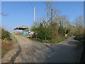
8
Metal Recycling Ltd
Small family run business specialising in scraping cars that lies off Rickney Lane near Downash.
Image: © Simon Carey
Taken: 3 May 2010
0.09 miles
10
Road Marsh
The name of the field according to the 1844 tithe map and part of Glynleigh Level.
Image: © Simon Carey
Taken: 3 May 2010
0.13 miles