IMAGES TAKEN NEAR TO
Downash, HAILSHAM, BN27 2RJ
Introduction
This page details the photographs taken nearby to BN27 2RJ by members of the Geograph project.
The Geograph project started in 2005 with the aim of publishing, organising and preserving representative images for every square kilometre of Great Britain, Ireland and the Isle of Man.

There are currently over 7.5m images from over14,400 individuals and you can help contribute to the project by visiting https://www.geograph.org.uk
Image Map
Images are licensed for reuse under creativecommons.org/licenses/by-sa/2.0
Notes
- Clicking on the map will re-center to the selected point.
- The higher the marker number, the further away the image location is from the centre of the postcode.
Image Listing (17 Images Found)
Images are licensed for reuse under creativecommons.org/licenses/by-sa/2.0
Image
Details
Distance
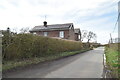
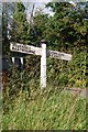
4
Rickney Lane junction with Saltmarsh Lane
Saltmarsh Lane becomes Downash Road around the corner.
Image: © Dave Spicer
Taken: 22 Jul 2013
0.11 miles
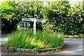
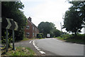
6
Direction Sign - Signpost by Saltmarsh Lane, Hailsham parish
Black iron cap finial - 2 arms; East Sussex wood by the UC road, in parish of Hailsham (Wealden District), Saltmarsh Lane, on grass island at junction of Station Road with Saltmarsh Lane.
Lost after Sep 2016.
Surveyed
Milestone Society National ID: SX_TQ5907
Image: © Milestone Society
Taken: Unknown
0.12 miles
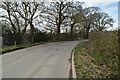
7
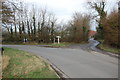
Junction with Station Road and Rickney lane
Image: © Julian P Guffogg
Taken: 29 Jan 2012
0.13 miles
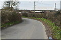
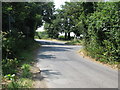
10
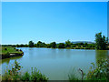
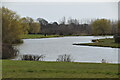
Fishing lake, Downash
Fed by the waters of Glynleigh Level. Folkington Hill is in the background.
Image: © Simon Carey
Taken: 16 Jul 2006
0.17 miles