IMAGES TAKEN NEAR TO
Archery Walk, HAILSHAM, BN27 2HF
Introduction
This page details the photographs taken nearby to Archery Walk, BN27 2HF by members of the Geograph project.
The Geograph project started in 2005 with the aim of publishing, organising and preserving representative images for every square kilometre of Great Britain, Ireland and the Isle of Man.

There are currently over 7.5m images from over14,400 individuals and you can help contribute to the project by visiting https://www.geograph.org.uk
Image Map
Images are licensed for reuse under creativecommons.org/licenses/by-sa/2.0
Notes
- Clicking on the map will re-center to the selected point.
- The higher the marker number, the further away the image location is from the centre of the postcode.
Image Listing (113 Images Found)
Images are licensed for reuse under creativecommons.org/licenses/by-sa/2.0
Image
Details
Distance
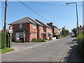
1
Archery Walk
Taken from the north west end
Image: © Terry Head
Taken: 3 Jul 2009
0.03 miles
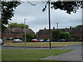
2

Archery Walk
Looking at the small green at the end of this road which was built after the Second World War. Beyond the green is Hailsham Common Pond.
Image: © Simon Carey
Taken: 15 Apr 2010
0.04 miles
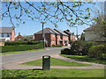
4

The Stringmakers
Post war estate on the south-east edge of Hailsham. The road links Archery Walk with Mill Road and commemorates the town's rope making business which sprang up in the late Victorian era.
Image: © Simon Carey
Taken: 15 Apr 2010
0.07 miles
8

Geese on Common Pond
Canadian geese on a large pond by Bell Banks Road and Station Road.
Image: © Oast House Archive
Taken: 26 Mar 2012
0.08 miles
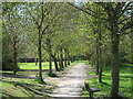
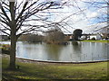
9

Common Pond
Until 1855 the area immediately west of Hailsham contained the town's common. After enclosure much of the land was developed initially for agriculture then for building as the town expanded. The only two remnants of the common are this pond and a recreation ground on Western Road.
Image: © Simon Carey
Taken: 15 Apr 2010
0.08 miles
10

Geese on Common Pond
Canadian geese on a large pond by Bell Banks Road and Station Road.
Image: © Oast House Archive
Taken: 26 Mar 2012
0.09 miles