IMAGES TAKEN NEAR TO
Freshfield Close, HAILSHAM, BN27 2DN
Introduction
This page details the photographs taken nearby to Freshfield Close, BN27 2DN by members of the Geograph project.
The Geograph project started in 2005 with the aim of publishing, organising and preserving representative images for every square kilometre of Great Britain, Ireland and the Isle of Man.

There are currently over 7.5m images from over14,400 individuals and you can help contribute to the project by visiting https://www.geograph.org.uk
Image Map
Images are licensed for reuse under creativecommons.org/licenses/by-sa/2.0
Notes
- Clicking on the map will re-center to the selected point.
- The higher the marker number, the further away the image location is from the centre of the postcode.
Image Listing (77 Images Found)
Images are licensed for reuse under creativecommons.org/licenses/by-sa/2.0
Image
Details
Distance
2
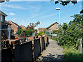
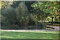
The Cuckoo Trail reaches urban Hailsham
The trail normally follows the old railway line, but here uses residential roads as the railway has been built over.
Image: © Robin Webster
Taken: 3 Sep 2011
0.02 miles
3
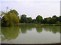
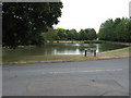
Hailsham Common Pond
What used to be a pond on a common is now part of a park within the small town of Hailsham. This view looks east.
Image: © Simon Carey
Taken: 8 Oct 2005
0.03 miles
4
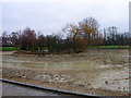
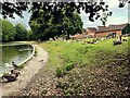
Hailsham Common Pond
Currently drained. Compare with Image]
Image: © Simon Carey
Taken: 12 Feb 2006
0.03 miles