IMAGES TAKEN NEAR TO
Garfield Road, HAILSHAM, BN27 2BD
Introduction
This page details the photographs taken nearby to Garfield Road, BN27 2BD by members of the Geograph project.
The Geograph project started in 2005 with the aim of publishing, organising and preserving representative images for every square kilometre of Great Britain, Ireland and the Isle of Man.

There are currently over 7.5m images from over14,400 individuals and you can help contribute to the project by visiting https://www.geograph.org.uk
Image Map
Images are licensed for reuse under creativecommons.org/licenses/by-sa/2.0
Notes
- Clicking on the map will re-center to the selected point.
- The higher the marker number, the further away the image location is from the centre of the postcode.
Image Listing (198 Images Found)
Images are licensed for reuse under creativecommons.org/licenses/by-sa/2.0
Image
Details
Distance
1
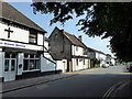
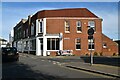
Former shop, Victoria Road
The property on the corner of Victoria Road and Garfield Road looks like it has been a shop, or maybe a pub.
Image: © Stephen Craven
Taken: 10 Nov 2012
0.01 miles
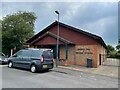
3
Hailsham Gospel Mission
The mission is on the corner of Station Road (foreground) and Garfield Road.
Image: © Stephen Craven
Taken: 10 Nov 2012
0.03 miles
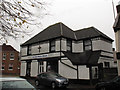
4
Kingdom Hall of Jehovah's Witnesses, Victoria Road
Image: © Oast House Archive
Taken: 14 Jul 2021
0.03 miles
5
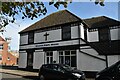
Railway Tavern, Hailsham
Pub on Station Road.
Image: © Oast House Archive
Taken: 19 Jul 2011
0.03 miles
6
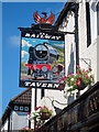
Railway Tavern sign
Sign for Image a pub on Station Road.
Image: © Oast House Archive
Taken: 19 Jul 2011
0.03 miles
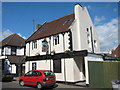
7
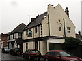
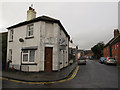
The Railway Tavern, Station Road
It's not difficult to see how this pub got its name.
Image: © Stephen Craven
Taken: 10 Nov 2012
0.03 miles