IMAGES TAKEN NEAR TO
New Bridge, HAILSHAM, BN27 1QF
Introduction
This page details the photographs taken nearby to New Bridge, BN27 1QF by members of the Geograph project.
The Geograph project started in 2005 with the aim of publishing, organising and preserving representative images for every square kilometre of Great Britain, Ireland and the Isle of Man.

There are currently over 7.5m images from over14,400 individuals and you can help contribute to the project by visiting https://www.geograph.org.uk
Image Map
Images are licensed for reuse under creativecommons.org/licenses/by-sa/2.0
Notes
- Clicking on the map will re-center to the selected point.
- The higher the marker number, the further away the image location is from the centre of the postcode.
Image Listing (46 Images Found)
Images are licensed for reuse under creativecommons.org/licenses/by-sa/2.0
Image
Details
Distance
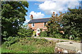
2
Lookers Cottage at New Bridge, Pevensey Levels
For a seasonal Comparison, see Image taken in Spring, earlier in the year.
Image: © nick macneill
Taken: 30 Aug 2010
0.01 miles
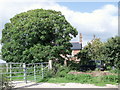
3
Lookers Cottage
A single cottage on New Bridge Road next to New Bridge which spans Hurst Haven.
Image: © Simon Carey
Taken: 4 Apr 2010
0.01 miles
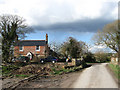
4
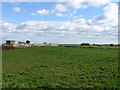
Lower Rigdens
The name of the field according to the 1839 tithe map and part of the Pevensey Levels. Adjacent to Lookers Cottage the field lies between Magham Sewer and Puckeridge Stream the latter just visible on the right.
Image: © Simon Carey
Taken: 11 Apr 2010
0.05 miles
5

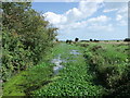
Magham Sewer
Viewed through the branches and the only view available unless the reeds are cleared next to New Bridge Road. The sewer rises near Spindle Bridge running parallel with Hurst Haven which it empties into through Newbridge Pumping Station nearby.
Image: © Simon Carey
Taken: 15 Apr 2010
0.05 miles
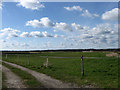
6
New Bridge Green
The name of the field according to the 1839 tithe map and part of the Pevensey Levels. Newbridge pumping station is on the left whilst the banks of Hurst Haven are to the right.
Image: © Simon Carey
Taken: 11 Apr 2010
0.06 miles
7
Hurst Haven at New Bridge, Pevensey Levels
Image: © nick macneill
Taken: 30 Aug 2010
0.06 miles
8

Hurst Haven
The main sewer for the western part of Pevensey Levels viewed from New Bridge. The disturbed water in the distance marks the point where Newbridge Pumping Station is depositing water from Magham Sewer into this watercourse.
Image: © Simon Carey
Taken: 4 Apr 2010
0.06 miles
9
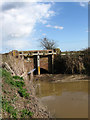
Bridge at New Bridge
Carrying New Bridge Road over Puckeridge Stream.
Image: © Simon Carey
Taken: 4 Apr 2010
0.07 miles
10
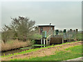
Newbridge Pumping Station
For lifting water from the levels up into Hurst Haven, a major drain beyond the pump house.
Image: © Robin Webster
Taken: 15 Nov 2011
0.07 miles