IMAGES TAKEN NEAR TO
Hawks Road, HAILSHAM, BN27 1ND
Introduction
This page details the photographs taken nearby to Hawks Road, BN27 1ND by members of the Geograph project.
The Geograph project started in 2005 with the aim of publishing, organising and preserving representative images for every square kilometre of Great Britain, Ireland and the Isle of Man.

There are currently over 7.5m images from over14,400 individuals and you can help contribute to the project by visiting https://www.geograph.org.uk
Image Map (Loading...)


Getting Data...Please wait
Leaflet Map data © OpenStreetMap
Images are licensed for reuse under creativecommons.org/licenses/by-sa/2.0
Notes
- Clicking on the map will re-center to the selected point.
- The higher the marker number, the further away the image location is from the centre of the postcode.
Image Listing (19 Images Found)
Images are licensed for reuse under creativecommons.org/licenses/by-sa/2.0
Image
Details
Distance
1
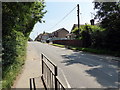
Upper Horsebridge Road, north of Hailsham
Note the old flour mill to the left of the picture which is now sadly boarded up.
Image: © nick macneill
Taken: 9 Feb 2011
0.10 miles

5
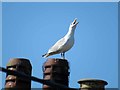
Seagull on chimney pot near to Hawthylands Road/Hawks Road junction
There are a lot of seagulls in the area and they are very noisy 24 hours/day.
See Image for a more distant view.
Image: © Andrew Tatlow
Taken: 30 Jun 2018
0.21 miles
6
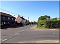
Hawthylands Road/Hawks Road junction
There is a large noisy seagull on the right chimney stack.
See Image for a close up.
Image: © Andrew Tatlow
Taken: 30 Jun 2018
0.21 miles