IMAGES TAKEN NEAR TO
Hawthylands Road, HAILSHAM, BN27 1HA
Introduction
This page details the photographs taken nearby to Hawthylands Road, BN27 1HA by members of the Geograph project.
The Geograph project started in 2005 with the aim of publishing, organising and preserving representative images for every square kilometre of Great Britain, Ireland and the Isle of Man.

There are currently over 7.5m images from over14,400 individuals and you can help contribute to the project by visiting https://www.geograph.org.uk
Image Map
Images are licensed for reuse under creativecommons.org/licenses/by-sa/2.0
Notes
- Clicking on the map will re-center to the selected point.
- The higher the marker number, the further away the image location is from the centre of the postcode.
Image Listing (12 Images Found)
Images are licensed for reuse under creativecommons.org/licenses/by-sa/2.0
Image
Details
Distance
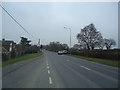
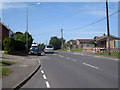
2
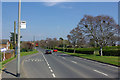
Bus stop and speed warning, Battle Road, Hailsham
The car is exceeding the 30 limit, and the sign has lit up.
Image: © Robin Webster
Taken: 8 Apr 2007
0.18 miles
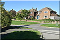
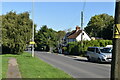
3
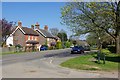
Cottages, Hailsham
On the A295 by the corner of Harebeating Lane.
Image: © Robin Webster
Taken: 8 Apr 2007
0.19 miles