IMAGES TAKEN NEAR TO
Battle Crescent, HAILSHAM, BN27 1EW
Introduction
This page details the photographs taken nearby to Battle Crescent, BN27 1EW by members of the Geograph project.
The Geograph project started in 2005 with the aim of publishing, organising and preserving representative images for every square kilometre of Great Britain, Ireland and the Isle of Man.

There are currently over 7.5m images from over14,400 individuals and you can help contribute to the project by visiting https://www.geograph.org.uk
Image Map
Images are licensed for reuse under creativecommons.org/licenses/by-sa/2.0
Notes
- Clicking on the map will re-center to the selected point.
- The higher the marker number, the further away the image location is from the centre of the postcode.
Image Listing (74 Images Found)
Images are licensed for reuse under creativecommons.org/licenses/by-sa/2.0
Image
Details
Distance
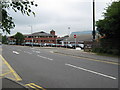
2
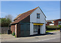
Hailsham Liberal Democrats
Modest premises!
Image: © Robin Webster
Taken: 8 Apr 2007
0.10 miles
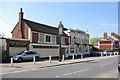
3
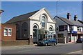
Hailsham Methodist Church
On High Street, opposite The Grenadier.
Image: © Robin Webster
Taken: 8 Apr 2007
0.10 miles
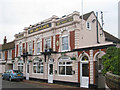
6
The Grenadier, Hailsham
On High Street. "Information about this pub is incomplete as it has not been visited by a member of the beerintheevening.com team". However, rated 4/10 by 3 users.
Image: © Robin Webster
Taken: 8 Apr 2007
0.12 miles
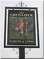
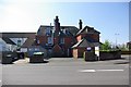
7
The Grenadier, Hailsham
A Harveys of Lewes pub on High Street.
Image: © Oast House Archive
Taken: 11 Dec 2010
0.12 miles
10
John's Fish & Chips - back view
From the Vicarage Lane car park.
Image: © Robin Webster
Taken: 8 Apr 2007
0.14 miles