IMAGES TAKEN NEAR TO
Rudyard Road, BRIGHTON, BN2 6UB
Introduction
This page details the photographs taken nearby to Rudyard Road, BN2 6UB by members of the Geograph project.
The Geograph project started in 2005 with the aim of publishing, organising and preserving representative images for every square kilometre of Great Britain, Ireland and the Isle of Man.

There are currently over 7.5m images from over14,400 individuals and you can help contribute to the project by visiting https://www.geograph.org.uk
Image Map
Images are licensed for reuse under creativecommons.org/licenses/by-sa/2.0
Notes
- Clicking on the map will re-center to the selected point.
- The higher the marker number, the further away the image location is from the centre of the postcode.
Image Listing (8 Images Found)
Images are licensed for reuse under creativecommons.org/licenses/by-sa/2.0
Image
Details
Distance
1
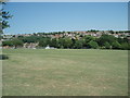
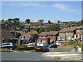
Rudyard Park
Park in the centre of Woodingdean
Image: © Paul Gillett
Taken: 23 Jun 2009
0.08 miles
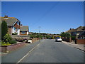
4

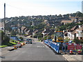
Crescent off Kipling Avenue
There are a number of these "crescents" running off Kipling Avenue, named after Rudyard Kipling who lived nearby in Rottingdean.
Image: © Paul Gillett
Taken: 23 Jun 2009
0.19 miles
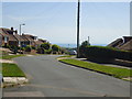
8
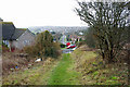
Woodingdean - looking down Balsdean Road
The near track aligning with Balsdean Road is a footpath link between Bexhill Road and a parallel bridleway behind the viewpoint.
Image: © Robin Webster
Taken: 27 Feb 2010
0.23 miles