IMAGES TAKEN NEAR TO
Sandhurst Avenue, BRIGHTON, BN2 6NG
Introduction
This page details the photographs taken nearby to Sandhurst Avenue, BN2 6NG by members of the Geograph project.
The Geograph project started in 2005 with the aim of publishing, organising and preserving representative images for every square kilometre of Great Britain, Ireland and the Isle of Man.

There are currently over 7.5m images from over14,400 individuals and you can help contribute to the project by visiting https://www.geograph.org.uk
Image Map
Images are licensed for reuse under creativecommons.org/licenses/by-sa/2.0
Notes
- Clicking on the map will re-center to the selected point.
- The higher the marker number, the further away the image location is from the centre of the postcode.
Image Listing (26 Images Found)
Images are licensed for reuse under creativecommons.org/licenses/by-sa/2.0
Image
Details
Distance
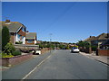
2
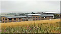
Buildings on the north edge of Woodingdean
Image: © Ian Hawfinch
Taken: 15 Aug 2020
0.11 miles
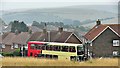
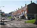
4
The Brighton Office Campus, Woodingdean
Image: © Stacey Harris
Taken: 19 Jun 2012
0.13 miles
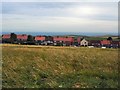
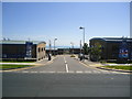
6
Woodingdean Business Park
Built on the site of a former industrial estate that was opened in 1961. Part of the estate included the old Sunblest bakery the smell of which made travelling past it on Falmer Road a very pleasant experience as a kid.
Image: © Simon Carey
Taken: 29 Aug 2011
0.15 miles
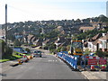
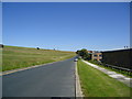
7
Field near Norton Drive
North of Bexhill Road in Woodingdean
Image: © Paul Gillett
Taken: 30 Jul 2012
0.15 miles