IMAGES TAKEN NEAR TO
Bopeep Lane, POLEGATE, BN26 6UL
Introduction
This page details the photographs taken nearby to Bopeep Lane, BN26 6UL by members of the Geograph project.
The Geograph project started in 2005 with the aim of publishing, organising and preserving representative images for every square kilometre of Great Britain, Ireland and the Isle of Man.

There are currently over 7.5m images from over14,400 individuals and you can help contribute to the project by visiting https://www.geograph.org.uk
Image Map
Images are licensed for reuse under creativecommons.org/licenses/by-sa/2.0
Notes
- Clicking on the map will re-center to the selected point.
- The higher the marker number, the further away the image location is from the centre of the postcode.
Image Listing (21 Images Found)
Images are licensed for reuse under creativecommons.org/licenses/by-sa/2.0
Image
Details
Distance
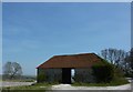
1
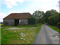
Shepherd's Cottage and Upper Barn
On the Old Coach Road, the cottage is numbered as are all residences on the Firle Estate.
Image: © Simon Carey
Taken: 13 Sep 2008
0.01 miles
2
Upper Barn
On the Old Coach Road and part of the Firle Estate.
Image: © Simon Carey
Taken: 13 Sep 2008
0.02 miles
3
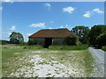
Upper Barn
Alongside Byway Alciston 11c.
Image: © Dave Spicer
Taken: 1 Jul 2012
0.03 miles
4
Upper Barn
On a bridleway to Bopeep Farm.
Image: © Peter Barr
Taken: 24 Apr 2010
0.04 miles
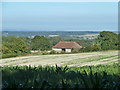
6
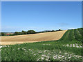
Corn Field near Upper Barn
On bridleway from South Downs down to Tilton Farm. Seen across the field is Upper Barn which is on a byway between Firle and Alfriston.
Image: © Oast House Archive
Taken: 10 Oct 2010
0.04 miles
7
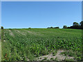
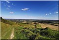
High Meadow
The name of the field according to the 1843 tithe map. The trees on the right mark the course of the Old Coach Road.
Image: © Simon Carey
Taken: 24 Jul 2010
0.12 miles
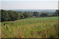
8
The Fifteen Acres
The name of the field according to the 1843 tithe map that lies at the foot of the northern scarp slope of the South Downs. Upper Barn is in the distance on the left.
Image: © Simon Carey
Taken: 24 Jul 2010
0.13 miles
9
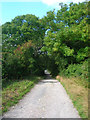
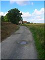
Old Coach Road
Beyond the trees is the crossroads of the bridleway that links Tilton to the Downs. This part of the road was turnpiked between 1752-1819 when it was superseded by a new road that is currently the A27. This road was closed down to prevent people using to avoid payment of tolls. It was resurfaced between Firle and Berwick in 2004/05 and is now a restricted byway.
Image: © Simon Carey
Taken: 13 Sep 2008
0.15 miles