IMAGES TAKEN NEAR TO
Berwick, POLEGATE, BN26 6TH
Introduction
This page details the photographs taken nearby to BN26 6TH by members of the Geograph project.
The Geograph project started in 2005 with the aim of publishing, organising and preserving representative images for every square kilometre of Great Britain, Ireland and the Isle of Man.

There are currently over 7.5m images from over14,400 individuals and you can help contribute to the project by visiting https://www.geograph.org.uk
Image Map
Images are licensed for reuse under creativecommons.org/licenses/by-sa/2.0
Notes
- Clicking on the map will re-center to the selected point.
- The higher the marker number, the further away the image location is from the centre of the postcode.
Image Listing (19 Images Found)
Images are licensed for reuse under creativecommons.org/licenses/by-sa/2.0
Image
Details
Distance
1
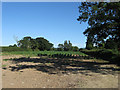
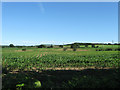
Little Meadow
The name of the field according to Arlington's 1843 tithe map that is hemmed in between Image and Image and considering the latter is an amalgamation of three larger fields it is quite a surprise to see this one has survived.
Image: © Simon Carey
Taken: 26 Jun 2011
0.04 miles
2
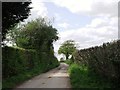
Access road to Claverham Manor, East Sussex
Image: © nick macneill
Taken: 12 May 2012
0.04 miles
3
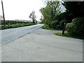
Wick Street passing Batbrooks Farm House
Image: © Dave Spicer
Taken: 7 May 2012
0.05 miles
5
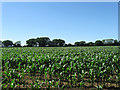
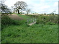
Three Crofts
The name of the field according to Arlington's 1843 tithe map. The rise in ground to the right in the near distance marks the location of Arlington Reservoir.
Image: © Simon Carey
Taken: 26 Jun 2011
0.07 miles
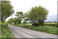
6
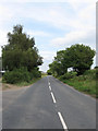
Wick Street
Until the 1970s this was the B2108 which ran from Seaford to Lower Dicker via Alfriston. It has since been downgraded to C status though it is still a popular route for those wishing to travel from the A27 to A22.
Image: © Simon Carey
Taken: 8 Aug 2010
0.08 miles
7
Further Townlands
The name of the field according to Arlington's 1843 tithe map that has been expanded to include Image to the north.
Image: © Simon Carey
Taken: 26 Jun 2011
0.11 miles
8
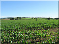
Gate Field
The name of the field according to Arlington's 1843 tithe map and viewed from said gate that allows the bridleway access to Wick Street, a minor C road. The rise in the near distance marks the location of Arlington Reservoir whilst Wilmington hill is visible in the distance to the left.
Image: © Simon Carey
Taken: 26 Jun 2011
0.13 miles
9
Bridleway to Wick Street
Running between the minor C road and Poundfield Corner the portion in the distance is part of the access road to Lower Claverham Farm. The bridleway itself is of some antiquity as it forms the parish boundary between Arlington and Chalvington.
Image: © Simon Carey
Taken: 26 Jun 2011
0.16 miles
10
Bridge on bridleway Arlington 24 to Arlington Reservoir
Image: © Dave Spicer
Taken: 7 May 2012
0.18 miles