IMAGES TAKEN NEAR TO
Station Road, POLEGATE, BN26 6TA
Introduction
This page details the photographs taken nearby to Station Road, BN26 6TA by members of the Geograph project.
The Geograph project started in 2005 with the aim of publishing, organising and preserving representative images for every square kilometre of Great Britain, Ireland and the Isle of Man.

There are currently over 7.5m images from over14,400 individuals and you can help contribute to the project by visiting https://www.geograph.org.uk
Image Map
Images are licensed for reuse under creativecommons.org/licenses/by-sa/2.0
Notes
- Clicking on the map will re-center to the selected point.
- The higher the marker number, the further away the image location is from the centre of the postcode.
Image Listing (84 Images Found)
Images are licensed for reuse under creativecommons.org/licenses/by-sa/2.0
Image
Details
Distance
1
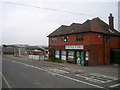
Berwick Stores, Station Road
The village shop on the northern side of the level crossing. Next door to it is the Berwick Service Station both a petrol filling station and garage.
Image: © Simon Carey
Taken: 29 Aug 2008
0.00 miles
2
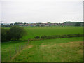
Looking Back to Berwick
From the small hillock south of Arlington Reservoir following the footpath back to Berwick. The fence at the bottom of the hill marks the parish boundary and once would have marked the eastern edge of Berwick Common on which the newer settlement of Berwick is built upon.
Image: © Simon Carey
Taken: 29 Aug 2008
0.02 miles
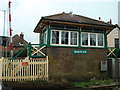
6
Berwick Signal Box
Built in 1879 for the London Brighton & South Coast Railway this signal box is Grade II listed
Image: © PAUL FARMER
Taken: 12 Jan 2019
0.02 miles
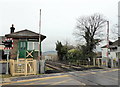
7
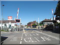
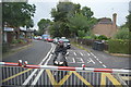
Level crossing at Berwick station
The Brighton, Lewes & Hastings Railway existed from February 1844 but only operated trains for a few weeks during June and July 1846 before it was amalgamated with other companies to form the London Brighton & South Coast Railway on 27th July 1846. Berwick station opened on 27th June 1846 and was extended in 1890. An English Heritage report called Berwick one of the most complete wayside country station ensembles.
This is the level crossing on Station Road with the station to the left. The next station to the left is Glynde and to the right is Polegate.
The Vanguard Way passes over the level crossing. The Vanguard Way is 66 miles long and runs from East Croydon to Newhaven. It connects the London suburbs to the south coast, via the North Downs, Ashdown Forest, South Downs National Park and the Cuckmere Valley. For more information about the Vanguard Way see http://www.vanguardway.org.uk/
Image: © Marathon
Taken: 11 Sep 2016
0.03 miles

9
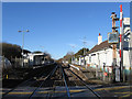
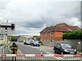
Berwick Station
Opened with the line in 1846 on what was Berwick Common then uninhabited. Since the turn of the century a small settlement has grown up around it.
Image: © Simon Carey
Taken: 2 Dec 2012
0.03 miles
10
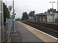
The down platform, Berwick Station, East Sussex
Image: © nick macneill
Taken: 3 Oct 2007
0.03 miles